Friday, March 25, 2022

The Missouri Ozarks

After a terrific overnight stay in Cuba, Missouri, we continued southwest on Route 66 (MO Highway ZZ). About four miles south of Cuba, in Fanning, Missouri, we passed the Fanning US 66 Outpost at 5957 Highway ZZ, where we saw the World’s Second Largest Rocking Chair.

World's Second Largest Rocking Chair in Fanning, Missouri (from Afar.com)

It was built in 2008 from steel pipes.

Route 66 soon runs along the southeast side of I-44 for a few miles. In St. James, Missouri, turn right (north) on Jefferson Street, cross I-44, then turn left (west) to continue on Route 66 on the northwest side of I-44.

About two miles after the turn, we saw a giant neon faucet at Murdon Concrete Product, 14241 Old Highway 66.

Neon faucet in St. James, Missouri

Route 66 continues on the north side of I-44 until about two miles outside of Rolla, Missouri, where it forks right onto MO 39. When MO 39 ends, turn right (southwest) onto MO 2000. In just a few hundred feet, Route 66 turns left onto US 63 south. In Rolla, Route 66 turns right (west) onto Kings Highway. In about half a mile, Kings Highway and Route 66 turn right onto MO 72. In a few hundred feet, there’s a traffic circle. Go three quarters of the way around the circle (enter at 6 o’clock, exit at 9 o’clock) onto Martin Springs Drive. (We were really glad it was morning and we were caffeinated when we drove through Rolla!)

About two miles past the circle, in Martin Springs, Missouri, Route 66 still has its original 1931 paving. Here the road has half curbs.

Half curbs along Route 66 in Martin Springs, Missouri

The half curbs were designed to guide drifting cars back on the road, but they actually increased rollovers. To make matters worse, Route 66 curves a bit sharply here as it approaches Little Beaver Creek, earning the nickname Deadman’s Curve.

Martin Springs Drive becomes Eisenhower Street in Doolittle, then MO 7300. When MO 7300 crosses I-44, we got on I-44 southwest for about 8 miles. We exited I-44 at MO Highway J, turning left then right to get back on MO Highway Z, which is the 1943-1957 “alignment” of Route 66. It soon expands into a four-lane divided highway. This was built during World War II to carry military vehicles to Fort Leonard Wood.

In about a mile, we turned right onto Trout Road, which parallels MO Highway Z. This was part of the 1926-1943 alignment of Route 66 through the tiny village of Hooker, and once again we got a feel for what it was like to drive cross country on Route 66 almost a hundred years ago.

We turned back onto the 1943-1956 alignment (MO Highway Z) and soon the highway passed through a cut in the hills

Hooker Cut, Missouri (from TheRoute-66.com)

If you’ve been on interstate highways through any hilly region of the United States, this cut may not look particularly impressive, but Hooker Cut was the deepest road cut in the United States for many years and an impressive engineering feat at the time.

After Hooker Cut, we turned left (south) on Teardrop Road, which is more of the 1926-1943 alignment. In about a quarter mile, we reached the tiny community of Devils Elbow, named not for the curve in Route 66 but for the curve in Big Piney River, where lumber floated downstream would get caught.

We passed the Elbow Inn, built in the early 1930s, damaged badly by floods in 2017, and now closed. Just past the Elbow Inn, a 1923 bridge still crosses Big Piney River.
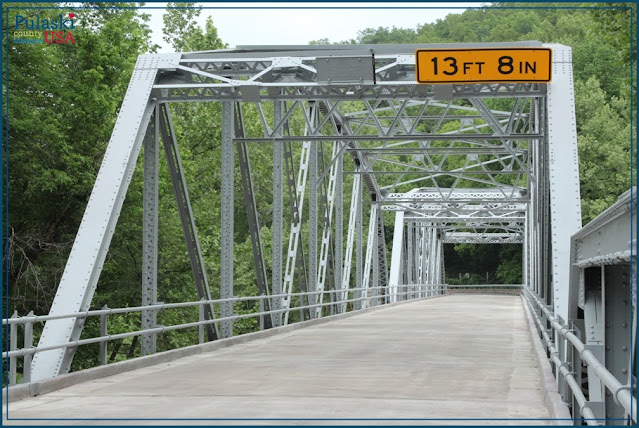
Devils Elbow Bridge, Missouri (from PulaskiCountyUSA.wordpress.com)

The bridge is so beautifully restored that I thought it was a replacement!

About a mile past Devil’s Elbow, Teardrop Road—the 1926-1943 alignment—rejoins the newer Route 66 alignment (MO Highway Z). We followed this about 3 miles into St. Robert, Missouri, passing the huge neon sign of the Uranus Fudge Factory in Uranus, Missouri, on the way.

Uranus Fudge Factory in Uranus, Missouri (from Route66News.com)

In St. Robert, Route 66’s east and westbound lanes split, and between them is a Route 66 relic: George Reed Roadside Park.

George Reed Roadside Park in St. Robert, Missouri (from MapQuest)

The park was built in 1955 as a roadside park for Route 66 travelers. It’s the only such park still in Missouri.

Route 66 soon crosses I-44 and the countryside becomes hilly—you’re in the Ozarks here. About 2 miles past George Reed Roadside Park, near Waynesville, Missouri, is Frog Rock, up on a hill on the right (north) side of the road.

Frog Rock in Waynesville, Missouri (from FourSquare.com)

In 1996, the city of Waynesville asked a local artist to carve the rock in the shape of a frog. The frog was named W. H. Croaker and Waynesville has organized Frogtober Fests to celebrate it.

Frog Rock is above a stretch of Route 66 that cuts through hills, bends around a curve, and has no shoulders, so I don’t recommend trying to stop and photograph it.

Waynesville has a good collection of historic buildings. The Old Stagecoach Stop, built in 1854 as a hotel, is now a museum open Saturdays in summer.

The Old Stagecoach Stop in Waynesville, Missouri (from OldStagecoachStop.com)

Past Waynesville, Route 66 (now Business I-44 and MO 17) slants back toward I-44, then runs along the north side of I-44 for about a mile. In Buckhorn, Missouri, MO 17 and Route 66 cross I-44, then turns southwest, away from I-44. This is a beautiful stretch of Route 66 through the Ozarks.

There are two “alignments” of Route 66 here, near Laquey (pronounced Lakeway). The 1930-1952 alignment of Route 66 is MO 17 for about 2 miles past Buckhorn, then forking right onto MO Highway AB.

We took the 1926-30 alignment. When Route 66 was first so designated in 1926, it was a patchwork of existing roads, and this 1926-30 segment is a good example of that. About a mile past Buckhorn, we turned right (west) on MO Highway P. We followed Highway P for about another mile, then turned left (south) on MO Highway AA. We followed Highway AA for about a mile and a half, then turned right (west) to rejoin the 1930-1952 alignment on MO Highway AB. 

Route 66 (MO Highway AB) heads back to I-44. Just before the interchange, in Gascozark, Missouri, is the ruins of the Gascozark Cafe.

Gascozark Cafe in Gascozark, Missouri

The Gascozark Café was built in 1931, with the curved top added in 1939. The multicolored “giraffe stone” is typical of buildings in the Ozarks. Over the years it’s had a gas station and been a bus stop.

We’d already seen a lot of abandoned Route 66 structures, but for some reason we found the Gascozark Café especially haunting, maybe because of its distinctive architecture, maybe because the sign is still on the building. We hope someone can find a way to restore this Route 66 treasure.

Past Gascozark, Route 66 follows along the south side of I-44, but its 1923 Gasconade River Bridge was closed during our trip, so at Gascozark we took I-44 to the next exit (MO Highway T). We then continued on Route 66 on the south side of I-44. In about 11 miles, Route 66 turns right (north) on MO Highway F, crosses I-44, then continues on the north side of I-44 into Lebanon, Missouri.

In Lebanon is one of Route 66’s iconic neon signs at the 1946 Munger Moss Motel.

Neon sign at Munger Moss Motel in Lebanon, Missouri (from MungerMoss.com)

Route 66 continues through Lebanon in Business I-44, then edges the north side of I-44 until Phillipsburg, Missouri, where it crosses I-44 and continues on MO Highway CC on the south side of I-44 to Marshfield, Missouri. In Marshfield, Route 66 becomes MO Highway OO. Just east of Springfield, Missouri, Route 66 becomes MO 744. Our next stop was Springfield, Missouri, one of the many great towns along Route 66.

Friday, March 11, 2022

Cuba, Missouri

Cuba, Missouri, is one of our favorite stops on Route 66! Our only regret is visiting on a Sunday afternoon in October, when the Visitor Center at the I-44 intersection and many of the shops downtown were closed.

We drove into town on Historic Route 66 (East Washington Boulevard), and the first thing we saw was our lodging for the night: the adorable and beautifully restored 1936 Wagon Wheel Motel. It's on the National Register of Historic Places.

Former restaurant of the Wagon Wheel Motel in Cuba, Missouri

The former restaurant, pictured above, is now a gift shop and registration desk. To the left of it, the former service station is now an office. Behind the gift shop are the motel units.

Some of the units of the Wagon Wheel Motel

Car service was once provided outdoors!
Car service bay at the Wagon Wheel Motel

We arrived at the Wagon Wheel before check-in, so we spent the afternoon exploring Cuba’s historic district. Cuba has 17 murals celebrating its history (get a map of them here or at the Visitor Center). The Missouri legislature has designated Cuba a “Route 66 Mural City.” But there are great historical buildings here too. In this post I’m sharing a few of our favorite murals and buildings.

A couple of blocks past the Wagon Wheel, a mural commemorates Bette Davis's visits to Cuba in 1948.

Mural commemorating Bette Davis's visits to Cuba

On the southwest corner of Washington Boulevard and Franklin Street is a former 1932 Phillips 66 Service Station. Some resources call it Carr’s Service Station.

Former 1932 Phillips 66 Service Station in Cuba, Missouri

The service station is now a restaurant called Weir on 66. Some of Cuba’s murals are where the garage doors used to be.

Three blocks west on Washington Boulevard, just before Fillmore Street, is another former gas station. This one was a Conoco station, built in the 1930s.

Former 1930s Conoco station in Cuba, Missouri

Two blocks further, at the corner of Washington Boulevard and South Smith Street, is Hayes Family Shoe Store with a great mural facing Washington Boulevard.

Mural at Hayes Family Shoe Store in Cuba, Missouri

 
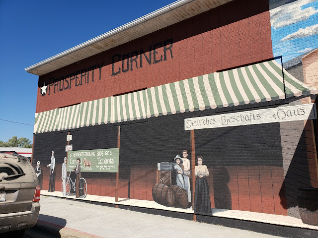
Around the corner on South Smith Street is another mural called “Properity Corner.” 

"Prosperity Corner" mural in Cuba, Missouri

We went two blocks south on South Smith Street, crossing the railroad tracks, then turned left (east) on South Main Avenue. On the southwest corner of South Main and Prairie Street is the 1908 City Jail.

1908 City Jail in Cuba, Missouri

We could take a peek inside.

Interior of City Jail in Cuba, Missouri

We then backtracked across the railroad tracks to Main Street and went several blocks west to see two old hotels at the corner of NE Main Street and Clay Street. On the northeast corner, at 601 NE Main Street, is the former Southern Hotel. This is where Bette Davis spent a night in 1948.

Former Southern Hotel in Cuba, Missouri (from theroute-66.com)

On the northwest corner, at 509 East Main Street, is the 1915 Hotel Cuba.

1915 Hotel Cuba (from theroute-66.com)

In the years before Route 66, Cuba was a stop on the Frisco Railroad. Both hotels were built facing the (now gone) railroad depot to serve passengers. When Route 66 came through behind them, the owner of the Hotel Cuba built a new entrance on the rear of the building to attract motorists.

Rear of Hotel Cuba (from Google Maps)

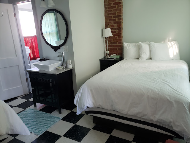
Back to the Wagon Wheel, where we checked into our adorable, super-clean room.

Our room at the Wagon Wheel Motel in Cuba, Missouri

No TV, no closet, no easy chair, no data ports, no blackout drapes—we loved it! Our stay gave us a real sense of what it was like to stay on Route 66 in the early 20th century.

In the evening we walked next door to the Missouri Hick Bar-B-Q for dinner.

Floor at the entrance to Missouri Hick Bar-B-Q in Cuba, Missouri

We wound up the evening enjoying the Wagon Wheel’s incredible neon.


I hope you can see why Cuba is one of our favorite Route 66 stops!

Tuesday, March 1, 2022

Eureka, Pacific, Villa Ridge, and Bourbon, Missouri

There are two Route 66 “alignments” southeast of St. Louis, Missouri. Like the two south of Springfield, Illinois, they are miles apart. The pre-1932 alignment mostly follows MO 100. The 1932-1977 alignment runs about 4-5 miles south of the earlier alignment, near I-44. We didn’t want to drive both, and we chose the southern 1932-1977 alignment because we wanted to see Times Beach, one of the most poignant stops on our Route 66 road trip.

The 1932-1977 Route 66 alignment leaves St. Louis on MO 366 (Chippewa Street). We passed the iconic Ted Drewes Frozen Custard but, unfortunately, early in the morning, well before it opened. Shortly after passing Ted Drewes, Chippewa Street becomes Watson Road. We passed a few old motels and motor courts before Watson Road ended and we had to get on I-44 westbound. We took I-44 for about 12 miles to the exit for the Route 66 State Park Visitors Center near Eureka, Missouri.

Route 66 State Park has two distinct sections separated by the Meramec River. On the eastern side of the river, the visitors center is in the former Bridgehead Inn roadhouse next to a fragment of Route 66 now called North Outer Road. Over the years, the roadhouse was also known as Steiny’s Inn.

Bridgehead Road House, now Route 66 State Park Visitor Center

Next to the Visitor Center are the remains of the 1932 Meramec River Bridge, which once took Route 66 travelers across the river.

Remains of Meramec River Bridge (from OurNextChapter.net)

The bridge decking was removed in 2012 after engineers deemed it unsafe for anyone to cross. Efforts are underway to raise funds to rehabilitate and reconstruct the bridge.

We loved the Visitor Center. It has a small museum, partly about Times Beach on the other side of the river and partly Route 66 artifacts, such as from long-gone motels. My husband loved this motorcycle.

Motorcycle at the Route 66 State Park Visitor Center

The Visitor Center also has a great gift shop full of Route 66 souvenirs—I bought a Route 66 jigsaw puzzle. The visitor center staffer was super-friendly and extremely helpful. We picked up a map of walking trails in the state park.

Then we drove to the western part of Route 66 State Park. Because the Meramec River Bridge is closed, we had to get back on I-44, get off at the next exit a few miles past the park, then double back to the park. (There are several turns; we set our GPS to Route 66 State Park and let it guide us.)

The western part of the park was once Times Beach . In the 1920s, lots here were sold by a newspaper, the St. Louis Star-Times, as a place for summer weekend getaways. By 1930, Times Beach was a true town with businesses as well as homes, and by the 1970s families were living here year round. They couldn’t afford to pave the dirt roads, so they hired someone to spread oil on them to keep the dust down. They didn’t know that the contractor also collected waste from nearby chemical plants and mixed that waste with the oil. The ground was contaminated with dioxin. In the 1980s the entire population was forced to evacuate, and all the town’s structures and soil were incinerated or buried in a huge mound. Altogether it was one of the worst environmental disasters in American history.

There are several trails around the former Times Beach. We took the “W Trail.” The trail description promised that we’d see a capped monitoring well and the mound where the town remains are buried. But we saw neither of these things along the trail. Instead we saw a park filled with so many trees that it was hard to believe that all the land here was incinerated only about 30 years ago.

Route 66 State Park "W Trail"

After our walk, we drove around the outer loop of the park and saw the mound. Then we continued on our Route 66 road trip by getting back on I-44. We took I-44 just a couple of miles to the Allenton/Six Flags exit, turned left (south) on Allenton Road, then right (west) on Business Loop 44. This is the 1932-1977 alignment of Route 66. We took this into the town of Pacific, Missouri, passing the now-closed 1932 Red Cedar Inn along the way.

Red Cedar Inn (from nps.gov)

In Gray Summit, Missouri, Route 66 leaves Business Loop 44 and becomes MO 100.  The older and newer Route 66 alignments meet here. Gray Summit is home of Purina Farms. We were hoping to see one of the dog shows here, but we would have had to wait a couple of hours for the next show, so we kept going on MO 100 for another two miles.

When MO 100 turned right (west) in Villa Ridge, Missouri, we kept going straight onto what Google Maps calls Historic US 66. Here we saw a Route 66 treasure: the 1948 former Tri-County Truck Stop, with lovely streamline moderne curves.

Tri-County Truck Stop in Villa Ridge, Missouri

We continued on Historic US 66, which edges the northwest side of I-44 for about 10 miles, then continues on the southeast side of I-44 to St. Clair, Missouri. In St. Clair, Historic Route 66 crosses back over to the northwest side of I-44. Although Route 66 closely parallels I-44, the roads are very different. Route 66 rises and falls to follow the terrain, which is hilly here as we approached the Ozarks. I-44 cuts through the hills for a level drive. 

In Sullivan, Missouri, we again crossed I-44 at MO 185 to stay on Historic Route 66, now back on the southeast side of I-44. We stayed on Historic Route 66 on the southeast side of I-44 into Bourbon, Missouri.

Bourbon has two cool things to see along Route 66. The first one is the now-closed Circle Inn Malt Shop.

Circle Inn Malt Shop in Bourbon, Missouri

The second cool thing to see in Bourbon is its water towers, labeled (duh) "Bourbon" and therefore the subject of many photos. The newer water tower is along I-44, while the older one is on Route 66 across from Bourbon High School.

Bourbon, Missouri, water tower

About a mile southeast of the Bourbon water tower on Route 66 is a bridge built in 1922. (If you want to find it on Google Maps, it’s just past Injoy Church.) Unfortunately, the bridge—and therefore Route 66—was closed when we visited, so we took I-44 from Bourbon to the Leasburg exit. Then we got back on Route 66 (now MO 508) into Cuba, Missouri—one of our favorite stops along Route 66.

St. Louis, Missouri

Spending every night of a Route 66 road trip in a different place can be draining, so we built a few “R&R” days into our trip with two-night stops. We wanted to stay at vintage hotels and motels as much as possible, and in St. Louis we decided to splurge on a stay the 1893 Hotel Saint Louis at 705 Olive Street.

Hotel Saint Louis (from stlmag.com)

The Hotel Saint Louis was originally the Union Trust Company, designed by Louis Sullivan, one of America’s most influential architects. The arched windows at the top of the building are one of his hallmarks. Sadly, the magnificent arched entrance and round windows were removed in a 1924 renovation.

Hotel Saint Louis before 1924 (from Missouri Historical Society)

One reason we were glad we chose the Hotel Saint Louis was its location: a 15-minute walk to the Gateway Arch. On a lovely, quiet Sunday morning, we walked down North 7th Street to Kreiner Plaza Park, where we had a beautiful view of the Old Court House and the Gateway Arch behind it.

Gateway Arch framing the Old Court House of St. Louis

Just past the arch is a huge bank of steps, perfect for watching boats and barges on the Mississippi River.

Steps leading from the Mississippi River to the Gateway Arch

We then walked north of the Arch through Gateway Arch National Park, where we got a great side view of the Arch.

Gateway Arch viewed from the north

We continued to walk north to Laclede's Landing, a redeveloped warehouse district. It was, unfortunately, disappointing. There were a few restaurants but not much else of interest.

We’re big fans of music from the 1950s and 1960s, so in the afternoon we drove out to Chuck Berry’s tomb.

Chuck Berry's tomb in Bellerive Gardens Cemetery

It’s in Bellerive Gardens Cemetery at 740 North Mason Road in the Creve Coeur section of St. Louis. The tomb is easy to spot, in the northwest corner of the cemetery. A lot of fans have left guitar picks and coins at the door. 

Guitar picks and coins left at Chuck Berry's tomb

We’re enormous fans of true frozen custard (very different from soft serve that’s sometimes called “custard”). So our next stop was to be at a Route 66 icon: Ted Drewes Frozen Custard at 6726 Chippewa Street.

Ted Drewes Frozen Custard (from goodfoodstl.com)

Unfortunately, on this gorgeous Sunday afternoon in October 2021, there was a HUGE crowd out front. We were not comfortable mingling in such dense crowds during the pandemic, so we reluctantly passed.

There are tons of other great things to see and do in St. Louis, but this was an R&R day for us, so we took things easy the rest of the day before continuing on Route 66 further into Missouri.