After leaving Williams, Arizona, we visited two towns along
Route 66 that are a study in contrasts: Ash Fork and Seligman.
We took I-40 west out of Williams for 20 miles, then exited
at Ash Fork (Exit 146). We turned right onto Business I-40, which is a tiny
Route 66 fragment, running only about a mile through Ash Fork before rejoining
I-40.
Business I-40 splits into two one-way streets through Ash
Fork. Lewis Avenue is westbound, and Park Avenue is eastbound. On the eastern
edge of Ash Fork, at 83 West Park Avenue, is the Ranch House Café. An episode of Restaurant: Impossible was filmed here in 2022.
 |
| Ranch House Cafe in Ash Fork (from Trip Advisor) |
About 2 blocks west of the Ranch House Café, at 242 Lewis
Avenue, is Zettler's Route 66 Store.
 |
| Zettlers Route 66 Store in Ash Fork |
A block west of Zettler's, at 314 Lewis Avenue, is a former 1958
Texaco station with a 1960 DeSoto on roof.
 |
| 314 Lewis Avenue in Ash Fork |
Next door, at 322 Lewis Avenue, is a building with what must have once been a
great sign.
 |
| 322 Lewis Avenue in Ash Fork |
After seeing Ash Fork, we rejoined I-40 for another 5 miles, then exited at
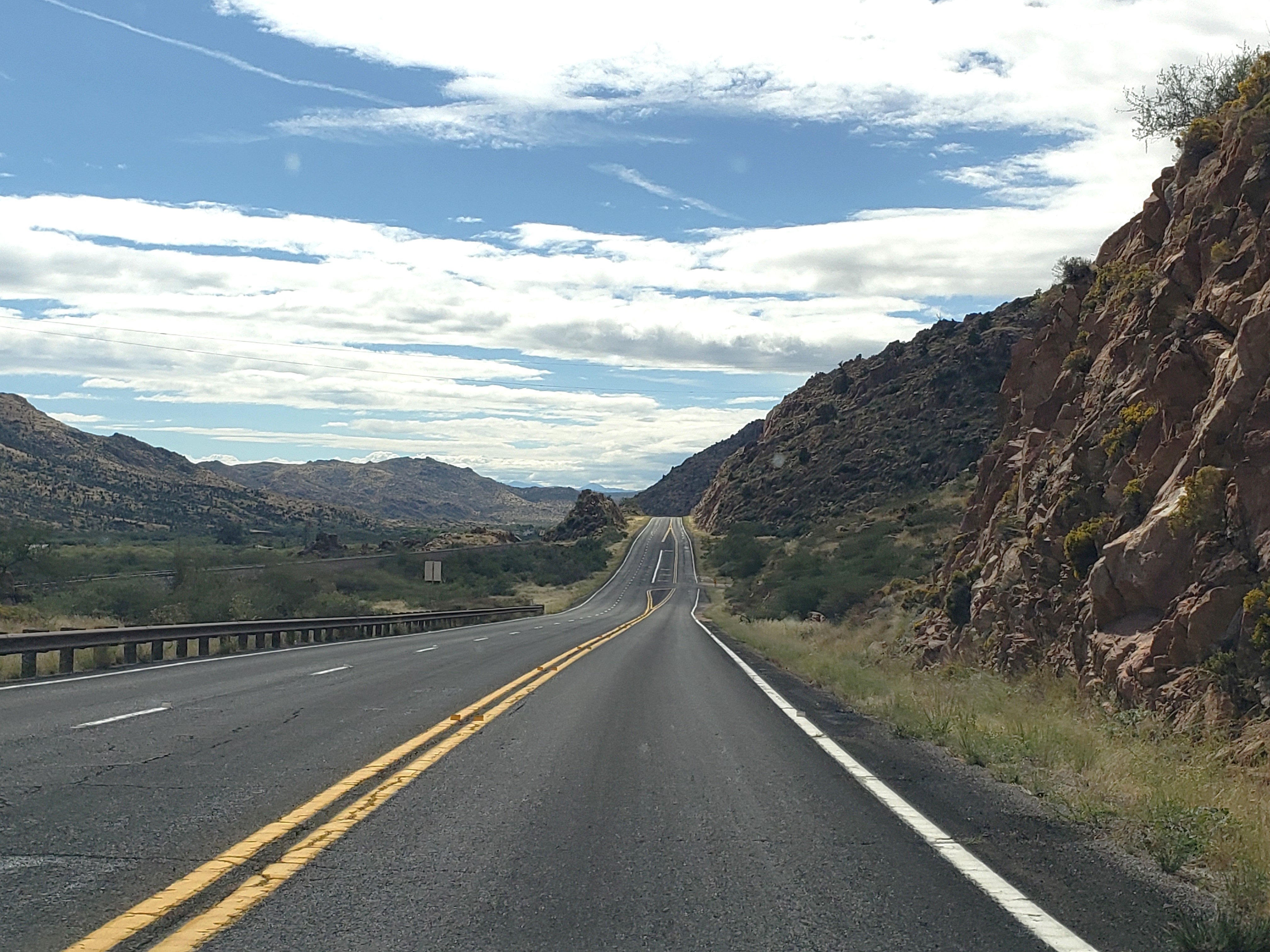
Crookton Road (Exit 139). We turned right on Crookton Road, marked on Google
Maps as West Old 66. This stretch of Route 66 was built in 1934. It’s the
beginning of the longest unbroken stretch of original Route 66 in the United
States—about 160 miles.
 |
| Route 66 (Crookton Road) looking west, near the I-40 exit for Crookton Road |
In about 18 miles, we reached one of the most important
stops on Route 66: Seligman, Arizona. It's a small town compared to, say, Williams, but it's much bigger and busier than quiet Ash Fork!
 |
| Route 66 in Seligman's historic district |
Springfield, Missouri, is considered the
birthplace of Route 66, but Seligman is the birthplace of Historic Route
66. As this article
explains, when US Route 66 was decommissioned in 1985, Seligman barbershop owner Angel Delgadillo
was determined to find a way to bring it back. He organized a meeting in
Seligman of a group that became the Historic Route 66 Association of Arizona.
That group got the state of Arizona to recognize the road from Kingman to
Seligman as Historic Route 66 and Seligman as Historic Route 66’s birthplace.
Other states followed Arizona's lead, creating their own Historic Route 66 associations and
making Historic Route 66 what it is today. Seligman inspired the town of
Radiator Springs in the movie Cars.
Today literally busloads of Route 66 travelers stop in
Seligman to pay homage to Angel Delgadillo, the father of Historic Route 66.
But Seligman is also worth a stop because, as the National Park Service
says, “Seligman offers today’s travelers a real understanding of what kinds of
commercial establishments were available to motorists travelling the Mother
Road.”
We found a really nice map of Seligman’s historic district
on the Route 66 Gift Shop’s website.
(Note that the map is upside down: the bottom of the map is north and the top
is south.) Wikipedia’s entry for Seligman is another good resource because it includes a list of some of Seligman's historic structures.
We started our walking tour of Seligman at Delgadillo’s Snow
Cap Drive In on the southeast corner of Historic Route 66 and Lamport Street.
 |
| Delgadillo's Snow Cap Drive In |
The National Park Service says the Snow Cap, “with its neon
lights and visual appeal, is one of the best examples of roadside architecture
in northern Arizona.”
 |
| Interior of the Snow Cap |
Tip: Watch out if you want mustard on your hot dog! (You'll have to visit to enjoy the gag.)
When we visited in 2022, the Snow Cap had the best social distancing
sign we’ve ever seen! (I'm a huge fan of Mary Poppins.)
 |
| Sign at the Snow Cap |
Historic Route 66 is not the original Route 66 through
Seligman. From 1926 to 1933, Route 66 was on Railroad Avenue, one block south
of Historic Route 66. The National Park Service notes that Railroad
Avenue is a chance to see what Route 66 looked like in its first years.
 |
| Railroad Avenue, looking east from Main Street |
The building on the northwest corner of Lamport Street and
Railroad Avenue (a block south of the Snow Cap) was once a Standard Oil Gas Bulk
Plant, built in the 1920s.
 |
| Former Standard Oil Gas Bulk Plant in Seligman |
Two doors west of the Standard Oil building is the
Delgadillo family home, where Angel was born and raised. It was built in 1920.
 |
| Delgadillo Family Home |
Just past Floyd Street on Railroad Avenue is Old Seligman
Garage and Bus Stop, built in 1905.
 |
| Old Seligman Garage and Bus Stop |
To the left (west) of the garage is the original Delgadillo
Barber Shop & Pool Hall, built in 1923.
 |
| Original Delgadillo Barber Shop & Pool Hall |
The Delgadillo family, along with other Hispanics families
in Seligman, faced discrimination and were not allowed in Pioneer Hall theater
and dance hall on Historic Route 66. So they socialized in this barber shop.
The barber shop closed in 1933 when Route 66 moved one block north.
Railroad Avenue runs along the, um, railroad. The railroad
ticket office, loading docks, and other railroad buildings are now gone, as is
the Havasu Harvey House, which was torn down in 2008.
Old Route 66 turns north on Main Street to rejoin Historic
Route 66. The National Park Service notes that commercial buildings built on
Historic Route 66 after the 1933 rerouting are “more ostentatious and exuberant
manifestations of roadside architectural style.”
On the southwest corner of Main Street and Historic Route 66
is the Route 66 Motoporium.
 |
| Route 66 Motoporium |
This was once the Copper Cart diner, built in 1952. This is
where Angel Delgadillo convened that first meeting of the Historic Route 66
Association of Arizona.
Just west of the Route 66 Motoporium is Historic Seligman
Sundries.
 |
| Historic Seligman Sundries |
Seligman Sundries was originally the Pioneer Hall theater and dance
hall, built in 1905. Hispanics were not allowed here, which is why they socialized at
Delgadillo’s Barber Shop on Railroad Avenue. In 1930 the building became Ted’s Fountain,
a drug store and soda fountain.
Across Historic Route 66 from Seligman Sundries is the Black
Cat Bar, rebuilt in 1963.
 |
| Black Cat Bar |
A couple of doors west of the Black Cat Bar is the Supai
Motel with a great neon sign.
 |
| Supai Motel |
Back at the intersection of Historic Route 66 and Main
Street, if you look north on Main Street, you can see a great mural on the
Seligman Grocery.
 |
| Seligman Grocery |
On the southeast corner of the intersection is a bandshell gazebo
built in 1900.
 |
| Seligman's Bandstand Gazebo |
Across Historic Route 66 from the gazebo is the former 1903
Pitts & Washington General Store, built in 1903.
 |
| Former Pitts & Washington General Store |
To the right (east) of the former general store is Canyon Lodge, built
in 1963.
 |
| Canyon Lodge |
Across Historic Route 66 from the Canyon Lodge is the Rusty
Bolt.
 |
| The Rusty Bolt |
You can see that the Rusty Bold was cobbled together from three buildings. One was once Miller’s Dry Cleaners, built in 1933, and another was once Thunderbird Indian Store, built in 1955. I'm not sure what the third building was.
Next to the Rusty Bolt, on the southwest corner of Historic
Route 66 and Floyd Street, is Route 66 Gifts. It’s in a former Shell station and
bus stop built in 1961.
 |
| Route 66 Gifts |
Across Historic Route 66 from Route 66 Gifts, on the northwest
corner of Historic Route 66 and Floyd Street, is Route 66 Roadrunner. It’s in an
old Shell station and Chevrolet garage, built in the mid-1930s.
 |
| Route 66 Roadrunner |
On the southeast corner of Historic Route 66 and Floyd
Street is the Deluxe Inn. It was built in 1932 as the Court Deluxe.
 |
| Deluxe Inn |
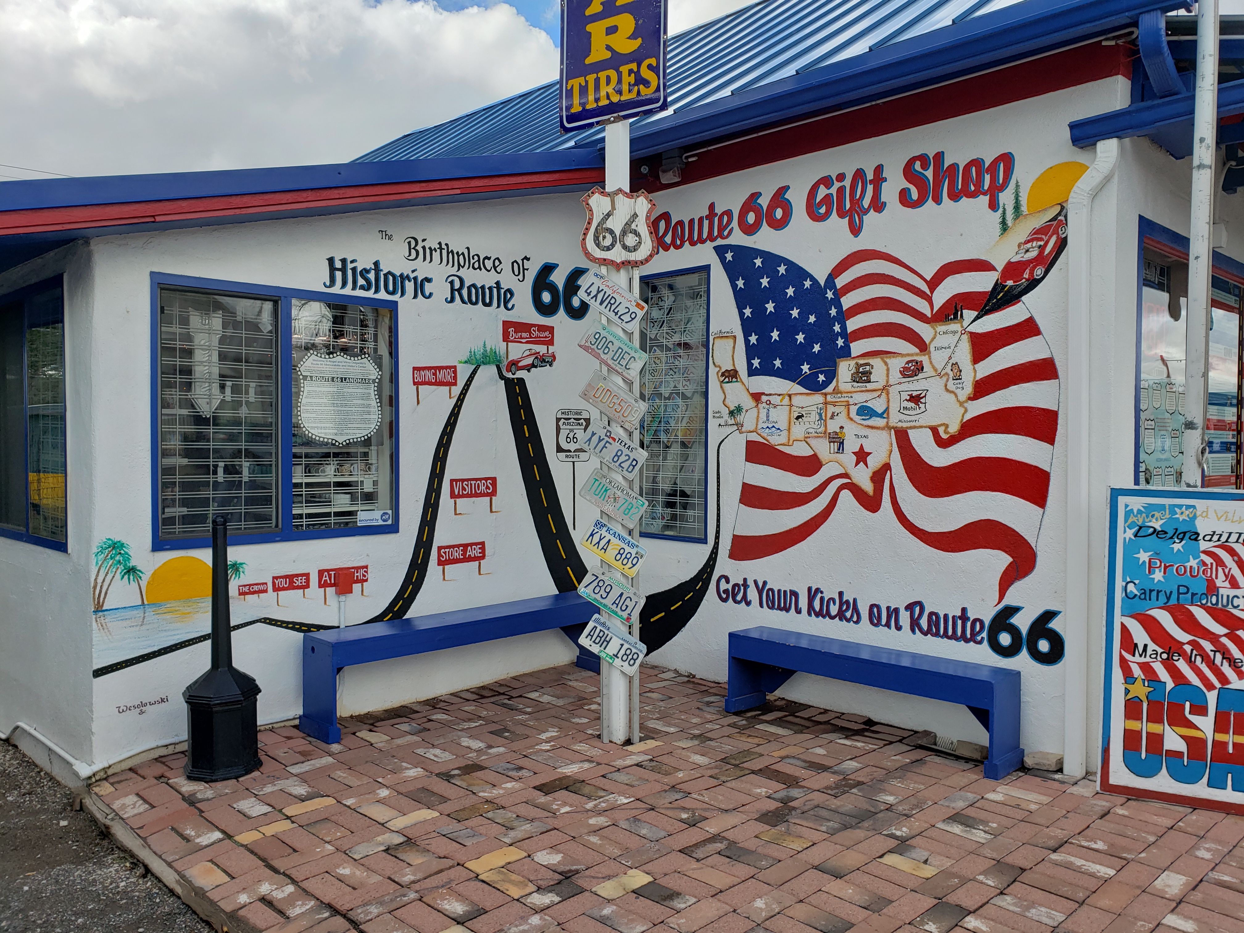
A couple of hundred feet east of the Deluxe Inn is Angel
& Vilma Delgadillo’s Original Route 66 Gift Shop.
 |
| Delgadillo's Original Route 66 Gift Shop |
The Gift Shop has a great Route 66 mural.
 |
| Mural on Delgadillo's Gift Shop |
A bench celebrates Angel Delgadillo’s retirement in 2022.
 |
| Bench next to Delgadillos' Gift Shop |
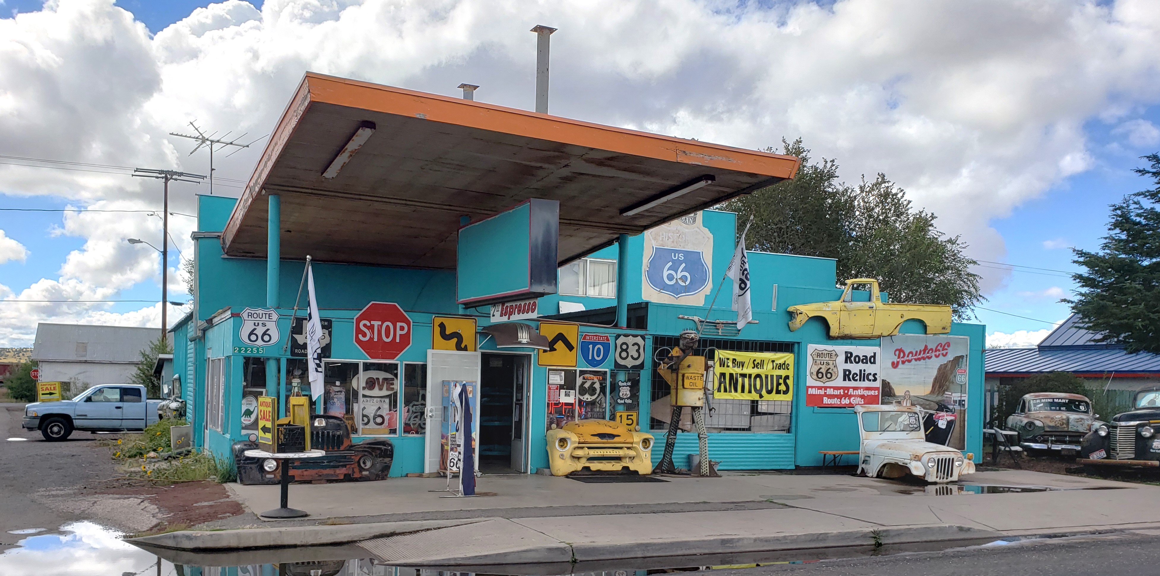
To the left of Delgadillo’s Gift Shop is Roadside Relics.
This was originally a Richfield Gas Station and Garage built in 1949.
 |
| Roadside Relics |
Across Historic Route 66 from Roadside Relics is the former Seligman
Feed Store. This was originally Donovan’s Garage & Texaco Station, built in
1936.
 |
| Former Donovan's Garage & Texaco Station |
About a half mile west of the Seligman’s historic district are two more Route 66 institutions. Westside Lilo’s restaurant
is at 22855 Route 66.
 |
| Westside Lilo's |
Across Route 66 from West Side Lilo’s is the Roadkill Café
in a building constructed in 1940.
 |
| Roadkill Cafe |
Behind the Roadkill Café are some Old West facades. They
were built as a tourist attraction and are not authentic.
We really enjoyed our stop in Seligman. It’s a great place
to get a feel for what the small towns along Route 66 used to be like as well
as honor Angel Delgadillo, the father of Historic Route 66. Plus…the town is darned
fun!
West of Seligman, Historic Route 66 continues.
 |
| Route 66 west of Seligman |
Our next stop: Peach Springs, Arizona.