Wednesday, December 29, 2021

Pontiac, Illinois

We loved our visit to Pontiac, Illinois . It’s a great example of those towns along Route 66 that have truly embraced their Route 66 heritage and transformed themselves into a special, worthwhile stop for today’s Route 66 roadtrippers.

About a mile before Pontiac, we turned left on N 1600 E Road, then immediately forked right onto E 1830 N Road (described as Pontiac Road in some resources). As soon as we turned off the Route 66 bypass, we saw the 1926 Old Log Cabin Inn & Restaurant.

Old Log Cabin Inn & Restaurant (from OnlyInYourState.com)

I read that, when the Route 66 bypass around Pontiac was built, the building was lifted and turned so it faced the new highway.

To take the 1926 “alignment” of Route 66 into Pontiac, curve left onto North Division Street, then curve right onto North Lincoln Avenue, then fork right onto North Ladd Street. Turn left (east) off this 1926 alignment at West Howard Street to get to Pontiac’s downtown.

Our first stop was the Illinois Route 66 Hall of Fame & Museum at 110 West Howard Street. 

Illinois Route 66 Hall of Fame & Museum in Pontiac

We parked on a street behind the museum and immediately saw several of the murals for which Pontiac is famous. 

A great photo op on the back wall of the Illinois Route 66 Museum

This delightful mural advertises Lipton Tea.
 
This mural advertises the Bloomington, Pontiac, & Joliet streetcar. 

Not a row of shops, just a mural that looks like one!

The museum, in a former firehouse, includes a visitors center with friendly, helpful staff, a map of all the town’s 23 murals, and brochures of other Pontiac attractions. The museum is mostly a collection of Illinois Route 66 memorabilia, arranged by location from north to south. In the same building, on an upper floor, is the Livingston County War Museum.

Pontiac is very walkable—most of the things we wanted to see were within walking distance. The sidewalks have painted footprints to guide you to the murals and museums.

A block south of the Route 66 museum is Livingston County Courthouse, built in 1875 and one of the most colorful courthouses we’ve ever seen.

Livingston County Courthouse in Pontiac, Illinois (from VisitPontiac.org)

Along the streets near the courthouse are shops and cafes. Just west of the Courthouse is Pontiac-Oakland Auto Museum, which we didn’t have time to visit. Instead, we walked south to East Water Street, then east to South Riverview Drive. Along the way, we saw some of the adorable small vehicles scattered around downtown Pontiac sidewalks.

One of the little cars around downtown Pontiac

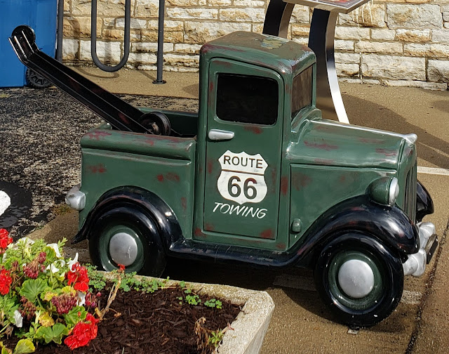
A little tow truck behind the Illinois Route 66 Museum

Two blocks south of East Water Street, just off South Riverview Drive, is one of Pontiac’s two swinging footbridges over the Vermilion River.  

1898 swinging footbridge in Pontiac, Illinois
Another view of Pontiac's 1898 swinging footbridge

We crossed the one first built in 1898; the other one was first built in 1926. The footbridges were built for workers living on the south side of Pontiac to commute to shoe factories on the north side. To be honest, they don’t really swing—they just bounce a bit as you walk on them.

Some of the streets in this section of Pontiac are paved in brick.

Some of the brick streets in Pontiac, Illinois

We drove out of Pontiac on Mill Street (IL 10) so we could see two more murals. Southbound travelers like us see a mural about the Vermillon River.

Vermilion River mural (from VisitPontiac.org)

The reverse side of the billboard welcomes northbound travelers to downtown Pontiac.

Downtown Pontiac mural (from VisitPontiac.org)

From Mill Street, we turned right (west) on West Reynolds Street to get back to the Route 66 bypass.

About 2 miles south of Pontiac, we saw one more gem: the former Illinois State Police Building, built in 1941 in art moderne style, with features like curves and glass bricks.

Former Illlinois State Police Building (from nps.gov)

It’s listed on the National Register of Historic Places but is now sadly abandoned.

You can see why we loved our visit to Pontiac! We were really glad we spent a couple of hours here. 

Our next stops were two more Illinois towns along Route 66: Lexington and Towanda.


Sunday, December 19, 2021

Dwight, Odell, and Cayuga, Illinois

Dwight, Illinois, is about 9 miles down Historic US 66 from Gardner. Here Historic US 66 runs along I-55. About two miles before Gardner, Historic US 66 splits away from I-55. About a mile after that split, we turned left onto South Brewster Road, which quickly turns into Dwight Road. This is the original 1926 Route 66 into Dwight. By this point in our Route 66 road trip, we were learning that we really liked taking the oldest “alignments” of Route 66. They gave us the best feel for what it was like to travel Route 66 almost 100 years ago.

Dwight Road soon merges into IL 47, which becomes North Union Street. To stay on the 1926 Route 66 alignment, turn right onto MacNamara Avenue, which becomes East Waupansie Street. But we wanted to see a couple of buildings in downtown Dwight, so we stayed on Union about 3 blocks further, then turned right onto East Mazon Avenue.

Those two buildings we wanted to see are on West Main Street. West Main is one-way, so from East Mazon we had to turn left on South Prairie Avenue, then left again onto West Main Street.

Our detour was worth it. At 119 West Main Street is Dwight’s lovely railroad depot, built in 1891.

1891 Dwight Railroad Depot on West Main Street

The huge arch and large “rusticated” stone are characteristics of Richardsonian Romanesque architectural style, which was very popular in the 1890s.

Directly across the street, at 122 West Main Street, is a bank designed by Frank Lloyd Wright and built in 1905. Once the First National Bank of Dwight, it’s now listed on Google Maps as “Dwight Banking Center - Peoples National Bank of Kewanee.”

1905 First National Bank of Dwight on West Main Street

I’m always struck by how modern Frank Lloyd Wright’s buildings look. If I didn’t know this was a Frank Lloyd Wright building, I would have guessed this was built in the 1950s, not in 1905!  I can’t help but wonder how the townspeople of Dwight felt about this building, built just 15 years after the train depot and certainly looking very different.

We then continued down Mazon Avenue, which has many lovely old buildings, to meet up with (West) Waupansie Street—the 1926 Route 66. On the corner is a Route 66 gem: Ambler's Texaco gas station, also known as Becker’s Marathon gas station. It is beautifully restored and on the National Register of Historic Places. It’s now a visitors center but, unfortunately, it was closed when we stopped by.

Ambler's Texaco in Dwight, Illinois

It has two sets of gas pumps, to catch customers coming from both roads at the intersection!

Side view of Ambler's Texaco in Dwight, Illinois

The part of the building behind the gas pumps dates to 1933. In the early days of automobile travel, gas stations were built to look like small houses, both to look warm and inviting to customers and to fit in with residential neighborhoods. The garage bays were added in the 1940s, when gas stations were evolving into automobile service stations.

From Ambler’s Texaco, we went south on South Old Route 66—not the Historic US 66 one block west. In about a mile, it merges into Historic US 66, which runs between I-55 and the railroad toward Odell, Illinois.

About four miles later, Historic US 66 again branches away from I-55. This road is the 1940s “alignment” that bypasses Odell. About a half mile further, we turned left onto Odell (or O’Dell) Road to take the 1926 alignment into Odell. Odell Road merges into Prairie Street. In just a block, we turned left onto North West Street to stay on the 1926 alignment.

At the corner of North West Street and West Hamilton Street are the remains of a pedestrian tunnel that once ran under North West Street.

Pedestrian tunnel under Route 66 at West Hamilton Street

By the 1930s, Route 66 traffic through town was so bad that the residents built this tunnel so they could safely cross the street. This is in a residential neighborhood, not the business district! It’s easy to understand why Route 66 was rerouted to bypass Odell by the 1940s.

Two blocks further, at 400 South West Street, is a Route 66 gem: the beautifully restored Standard Oil gas station

Odell Standard Oil gas station

It was built in 1932 and is on the National Register of Historic Places. It’s now a visitors center, but unfortunately it was closed when we stopped by.

South of the Standard Oil gas station, South West Street rejoins Historic Route 66 (the bypass in the 1940s) and once again runs between I-55 and a railroad. Just north of Cayuga there’s supposed to be a barn with “Meramec Caverns” painted on the side, but we didn’t see it.

By the time we reached Cayuga, we noticed what looked like stretches of an abandoned concrete road running parallel to Route 66 on our right. The photo below is of the abandoned road, facing south, with the road we were driving to the left.

Now-abandoned 1940s Route 66 between Cayuga and Chenoa, Illinois (from Wikimedia Commons)

The abandoned roadbed was once the 1920s Route 66 from Cayuga, through Pontiac, and on to Chenoa. It was paved with slabs of Portland cement that were 6 inches deep and 18 feet wide. That road could not support heavy wartime vehicles during World War II. So during the war, the road was paved over with new concrete, this time 10 inches deep and 24 feet wide. In the 1950s, Route 66 was expanded to a 4-lane highway by adding two lanes to the east—the road we were now driving on and that you can see on the left side of the photo.

Once I-55 was built, there was no need to maintain a four-late Route 66 alongside it. So the two southbound lanes—the original Route 66, topped with a new road during World War II—were simply abandoned and the two northbound lanes converted into a two-lane road. 

Next stop: Pontiac, another one of Route 66’s gems.


Thursday, December 9, 2021

Wilmington, Braidwood, and Gardner, Illinois

South of Joliet, Route 66 is mostly on IL 53. This stretch between Joliet and Wilmington was built during World War II to carry heavy military vehicles. It’s now on the National Register of Historic Places.

In Wilmington, we saw our first “giant”! This one is called the Gemini Giant.

Gemini Giant at the Launching Pad Drive In in Wilmington, Illinois

In pre-internet days, a lot of roadside businesses focused their advertising efforts on catching the eye of passing travelers with something large and dramatic, such as neon signs and giant figures. In the early 1960s thousands of giant fiberglass men were made in California, largely from the same mold. The first one was designed to look like Paul Bunyan, with the hands positioned to hold an ax. He was commissioned to advertise the Paul Bunyan Café in Flagstaff, Arizona (on Route 66!!!) and may now be one of two on the campus of Northern Arizona University. But these giant men were soon manufactured to advertise other businesses, with the ax replaced—sometimes awkwardly—with other objects. So many of them held mufflers that these giant men are sometimes referred to as Muffler Men no matter what they’re holding.

The Gemini Giant, holding a rocket ship, is at the 1960s Launching Pad Drive In at 810 East Baltimore Street in Wilmington, Illinois.

Launching Pad Drive In in Wilmington, Illinois

Just a few blocks further down Route 66 is an adorable Sinclair dinosaur on top of BTI Tire & Alignment (formerly G&D Tire) at 200 East Baltimore Street, Wilmington, Illinois.

Sinclair Dinosaur atop BYI Tire & Alignment in Wilmington, Illinois

South of Wilmington, Route 66 (IL 53) runs straight beside a railroad track. In Braidwood, we saw the 1962 Polk-a-Dot Drive-In.

Polk-a-Dot Drive In in Braidwood, Illinois (from TravelBlog.org)

It’s now decorated with some fiberglass statues of celebrities.

Polk-a-Dot Drive In in Braidwood, Illinois (from RoadsideAmerica.com)

South of Braidwood, Route 66 (IL 53) continues alongside the railroad tracks until just before Gardner, Illinois, where it splits off to the east to bypass Gardner. Here we took a quick detour off Route 66 to see a couple of historic sites in Gardner, at the corner of North Center Street and East Mazon Street. The first is a two-cell jail built in 1906.

Two-cell jail in Gardner, Illinois

The jail door was open when we visited, so we were able to peer in and see the two cells.

Interior of two-cell jail in Gardner, Illinois

Right next door is the Streetcar Diner.

Streetcar Diner in Gardner, Illinois

Most early 20th century diners were manufactured to look like train cars. What’s cool about this diner is it began life as a real streetcar in Kankakee, Illinois, possibly as early as the 1890s. When Kankakee replaced streetcars with buses in the early 1930s, one of the streetcars was moved to Gardner and became a diner on Route 66.

The Streetcar Diner was restored in 2001 and moved to this location in 2010 to better preserve it. You can peek in the windows and imagine getting a meal there.

Interior of Streetcar Diner in Gardner, Illinois

In front of the Streetcar Diner is a sign for the Riviera Restaurant featuring Betty Boop.


Riviera Restaurant sign in Gardner, Illinois

The 1928 Riviera was a Route 66 institution until it burned in 2010. The sign was moved here for safekeeping.

IL 53 ends on the southern edge of Gardner. From here, we took “Historic US 66,” which runs along I-55 to our next stops: Dwight and Odell, Illinois.


Tuesday, November 23, 2021

Joliet, Illinois

Joliet is the first Route 66 town that's outside of Chicago's suburbs. It was thus the first town that felt to us like a Route 66 town. And that made it a fun visit. By the time we reached Joliet, we were ready for a break, so our first stop was at Rich & Creamy, a vintage soft ice cream stand featuring a silhouette of the Blues Brothers on the roof (look to the left of the pink ice cream cone). 

Rich & Creamy in Joliet

Rich & Creamy is in Joliet's Kicks on 66 Park. After some ice cream, we walked through the park.

Sign at Kicks on 66 Park in Joliet, Illinois

There are some informative wayfinding signs near the Rich & Creamy. 

Wayfinding signs in Kicks on 66 Park in Joliet, Illinois

The walk is pleasant, but views of the Des Plaines River and Joliet Prison are blocked by trees. Overall this is a good place to stop if you want to stretch your legs or get some soft ice cream, but otherwise keep going. (Tip: Rich & Creamy and the Kicks on Route 66 Park do not have rest rooms, but gas stations and fast-food restaurants are a few blocks away.)

Take North Chicago Street rather than IL 53 into downtown Joliet. North Chicago Street was the earliest Route 66 route through Joliet, and there are some interesting things to see along it. In downtown Joliet, the intersection of North Chicago Street and Cass Street is the intersection of Route 66 and the old Lincoln Highway, now US 30. The Lincoln Highway was America’s first cross-country road, running from New York to San Francisco.

Intersection of Route 66 and the Lincoln Highway in Joliet

Practically next door at 9 West Cass Street is a new attraction that wasn’t yet open when we visited: the Illinois Rock & Roll Museum on Route 66.

Future home of the Illinois Rock & Roll Museum on Route 66 in Joliet

And a block and a half south on Chicago Street is the magnificent 1926 Rialto Square Theater.

Rialto Square Theatre in Joliet (photo from Venuworks.com)

The 1858 Joliet Prison is not on Route 66. If you want to see it, you’ll have to backtrack north on IL 171 on the east side of the Des Plaines River. It’s an impressive pair of buildings (on both sides of the highway), but the information kiosks that I read would be in the south parking lot are now gone, and the building itself was closed when we visited.

Joliet Prison

Next stops coming up: three small towns along Route 66 in Illinois: Wilmington, Braidwood, and Gardner.

Chicago, Cicero, and Willowbrook, Illinois

Chicago is where Route 66 begins! While we initially wanted to experience Route 66 end to end, we knew we'd spend a lot of time in traffic if we started in downtown Chicago. So we decided to see Route 66's Chicago-area sights on a separate trip to Chicago. We headed from O'Hare south to start our Route 66 experience in Willowbrook, home of Dell Rhea's Chicken Basket. Keep reading for more on that.

But if you truly want to start at the beginning, here are some key sights in Chicago and its suburbs.

I think for many people, the main Route 66 sight in Chicago is the sign announcing the beginning of Route 66. It’s at the corner of South Michigan Avenue and East Adams Street, right across from the Art Institute of Chicago.

Sign marking the start of Route 66 in Chicago (photo from VisitTheUSA.com)

But this has been the beginning of Route 66 only since the 1950s. From 1926 to the mid-1930s, the beginning of Route 66 was a block south, at the intersection of South Michigan Avenue and Jackson Boulevard. The beginning of Route 66 was moved to East Adams Street when Jackson Boulevard became a one-way street going east. Today, the original beginning of Route 66 is marked, ironically, with a sign announcing the end of Route 66 for eastbound travelers.

Jackson Boulevard isn't a bad place to start your Route 66 journey, even if it does now go in the "wrong" direction. Chicago tour guide David Clark pointed out to me that only four buildings along Jackson Boulevard have been built since 1977, making it one of the best preserved stretches of Route 66!

Two other Route 66 icons in Chicago are classic restaurants. The Berghoff, two blocks west of the Route 66 sign on East Adams Street, first opened in 1898 and has a great neon sign.

Berghoff Restaurant in Chicago (photo from TripAdvisor)

Several blocks west, at 565 West Jackson Boulevard, is Lou Mitchell's restaurant, open since 1949 for breakfast and lunch. It's on the National Register of Historic Places and still has its original neon sign.

Lou Mitchell's restaurant in Chicago (photo from NPS.gov)

One of the first Route 66 sights south of downtown Chicago is the now-closed 1925 Castle Car Wash at 3801 Odgen Avenue. While some resources describe it as in Cicero, its actual address is Chicago.

Castle Car Wash in Cicero, Illinois (photo from Viviendodeviaje.com

About 3 1/2 miles further down Ogden Avenue is the 1950s Henry’s Drive In at 6031 Ogden Avenue in Cicero. It's famous for its giant neon hot dog sign.

Henry's Drive In in Cicero, Illinois (photo from Route66travelers.wordpress.com)

Note that, if you stop for a hot dog at Henry's, in the Chicago area it's considered bad taste (literally!) to eat it with ketchup, as this sign from a Chicago food stand explains.

Sign at Chicago food stand (photo from community.spiceworks.com)

As I've already explained, we decided to skipped all the above sights and made our first stop Dell Rhea's Chicken Basket in Willowbrook (some guidebooks say it's in Hinsdale). For the drive from O'Hare, we didn’t try to stay on Route 66. We simply plotted a route on Google Maps that avoided highways and tolls.

It was a good thing that we used Google Maps, because Dell Rhea’s Chicken Basket would be hard to find otherwise. The segment of old Route 66 that it sits has been largely cut off by I-55 and other highways and requires a circuitous route to reach. But it was worth it to see a restaurant that’s been serving chicken since 1946. It's also on the National Register of Historic Places and has another great neon sign.

Dell Rhea Chicken Basket in Willowbrook, Illinois

We had hoped to have lunch at Dell Rhea’s, but the scheduling fates weren’t with us. We didn’t get here til mid-afternoon, so after a moment admiring the sign, we moved on. We took I-55 to the exit for Joliet Road south (IL 53) and followed it into Joliet.. Here we started to see some references to Route 66 in business names along the way, and the Chicago suburbs started to give way to rural Illinois. Our Route 66 experience was underway!

For more information on this stretch of Route 66, visit https://www.thefirsthundredmiles.com/