Wednesday, April 19, 2023

Topock, Arizona, and Needles, California

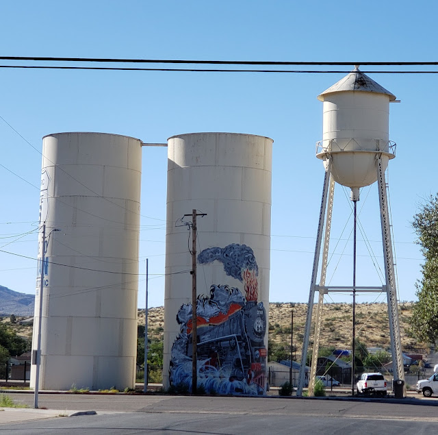
The Oatman Highway (AZ 10) ends just after passing the town of Topock, Arizona. As the road approaches I-40, it curves right (west) to briefly parallel railroad tracks. It then makes a hairpin turn to cross under the railroad tracks, then go east between the railroad and I-40. Here, on the north side of the road next to the railroad tracks, is a water tower built in 1908.

Topock Water Tower

When AZ 10 crosses I-40, the long unbroken stretch of original Route 66, which began east of Seligman, Arizona, ends. You must get on I-40 to cross the Colorado River and enter California. But, if you can safely pause on the overpass over I-40, you can see two sights. To the east are some mountains called The Needles. They appeared in the movies The Grapes of Wrath and Easy Rider.

The Needles, south of Topock

And to the west is a beautiful bridge.

Old Trails Bridge near Topock

This bridge was built in 1916, a decade before the National Old Trails Highway became Route 66. I’ve seen it called the Old Trails Bridge, Trail Arch Bridge, and Old Trails Arch Bridge. Today it only carries a pipeline; it is closed to traffic and pedestrians.

Instead of getting on I-40 into California, we took a detour off Route 66. We went east on I-40 to Exit 9 (AZ 95), then took AZ 95 south to Lake Havasu City, Arizona. Lake Havasu is a real contrast from Route 66, because it was created in 1963, decades after Route 66 was established. It’s most famous as the home of London Bridge, which was installed here in 1971.

London Bridge in Lake Havasu City

London Bridge at night
We spent the night at the Holiday Inn Express, which has great views of London Bridge, and ate dinner at The Chair next to the bridge. It was a very pleasant break—to us, it was worth the detour. 

The next morning we backtracked to I-40 west, now crossing the Colorado River and entering California. (Tip: Get gas before entering California—it’s much more expensive there.)

We wanted to take the original 1930s Route 66 alignment to Needles, so about a mile after crossing into California, we took the exit for Park Moabi Road, turning right (north) onto Park Moabi Road. In about a mile, we turned left (west) on National Trails Highway—the original Route 66. We soon encountered this:

National Trails Highway west of Park Moabi Road

At the time, we thought National Trails Highway was blocked off. Afterwards, I studied my maps again and I now think National Trails Highway veers left, crossing under the railroad tracks. No matter—it would have been far too rough for us to feel comfortable driving. So we backtracked to I-40 and continued west on I-40 to the exit for Five Mile Road. We turned left (west) on Five Mile Road. Here the National Trails Highway that we wanted to drive merges into Five Mile Road, so we were back on the 1930s Route 66 alignment. In about a mile, Five Mile Road merges into US 95—still the 1930s Route 66 alignment. 

US 95 (1930s Route 66 alignment) south of Needles

We continued on US 95 north about five miles into Needles, California. Here US 95 (Route 66) becomes Broadway Street.

Just off Route 66, at 91 Desnok Street, is the adorable 66 Motel, built in 1945-1947.
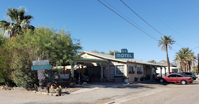
66 Motel in Needles

The 66 Motel has a great old sign on Route 66, pointing travelers to the motel.

66 Motel sign

About 3 blocks north of the 66 Motel on Route 66, just past Palm Way, is the former Old Trails Inn. It opened in the 1930s as the Palms Motel.

Former Palms Motel in Needles

Across Route 66 from the Old Trails Inn, a borax wagon welcomes visitors to Needles.

Borax wagon in Needles

The wagon is a tribute to the wagons that once hauled borax out of nearby mines. (We’re old enough to remember TV commercials for “20 Mule Team Borax.”) This wagon was once in front of the long-gone El Rancho Motel a bit north of here.

Four blocks north of the borax wagon is a beautiful 1930s art deco building at 725 West Broadway Street.

Former Claypool & Company Hardware

The building once housed Claypool & Company Hardware. Today it houses Palo Verde Community College.

A block past the Claypool building, we turned right on F Street, then left on Quinn Court. On the right (north) side of Quinn Court is the beautiful El Garces Hotel.

El Garces Hotel

The El Garces Hotel was built in 1908 to replace a train depot that burned. It was designed to look like a Greek temple. It was one of the Harvey House chain built primarily to serve railroad passengers. (See my post on Winslow for more information on the Harvey Houses.) It is open for tours by appointment only; inquire at the Needles Regional Museum across the street.

On the north corner of the park in front of the hotel is a great sign honoring both Route 66 and Needles' railroad heritage.

Route 66 sign in front of El Garces Hotel

And across Quinn Court from the hotel is a Route 66 gem: the Needles Regional Museum in a former J.C. Penney’s department store.

Needles Regional Museum

The building has a great mural on its right (north) side.

Needles Regional Museum mural

The museum itself is a wonderful Route 66 stop. At the entrance is a statue of Spike, Snoopy’s brother.

Spike (and a lot of other cool stuff) at the Needles Regional Museum

Charles Schulz, who created the Peanuts comic strip, lived in Needles as a child for a few years. In the strip, Spike lived in the desert but periodically came into Needles.

 The museum staff were wonderful—in a few minutes we learned a great deal about the Needles region, including the Harvey House across the street and the Old Trails Bridge near Topock. We wish we could have spent even more time here!

 We returned to Broadway Street via G Street. On the northeast corner of Broadway and G Streets is another cool Route 66 sign.

Route 66 sign on the corner of Broadway & G Streets

We turned right (north) on Broadway Street and drove about three-quarters of a mile before turning left (west) to stay on Broadway Street and Route 66. Here Broadway Street is also called Needles Highway. In about half a mile Needles Highway bends a bit to the right. Here a restored Texaco station is at 2211 Needles Highway.

Texaco station in Needles, with Route 66's ever-present trains running behind it

Across Needles Highway from the Texaco Station, at 2302 Needles Highway, a Chinese restaurant is in a former Denny’s, complete with classic boomerang roof.

Former Denny's in Needles

About a quarter mile past the former Denny’s is a Route 66 institution: the Wagon Wheel Restaurant at 2420 Needles Highway.

Wagon Wheel Restaurant in Needles

There are very few services between Needles and Ludlow, California—a good 2½ hour drive if you’re taking the original Route 66. So consider getting gas and something to eat here and make sure you have plenty of water and snacks. If you’re using a GPS, set it before you leave, as cell phone service will be spotty.

After the Wagon Wheel, the Needles Highway crosses I-40. In about a mile, the road forks, with National Old Trails Road on the left and Needles Highway on the right. We took the National Trails Road on the left. When it ended in about a mile, we turned left (west) on West Park Road, then took I-40 north toward CA 66, one of the most desolate, haunting stretches of Route 66, crossing the Mojave Desert.

Monday, April 10, 2023

Oatman and the Oatman Highway

As I explained in my last post on Kingman, Arizona, we followed Route 66 out of Kingman until it ran along I-40. We then took the first right turn to cross I-40, then left on AZ 10, to continue on one of the most famous stretches of Route 66: the Oatman Highway. This was Route 66 between Kingman and Topock, Arizona, until 1952, when a new Route 66 “alignment” was built along what’s now I-40.

The Oatman Highway is known for three things: some of the most beautiful scenery along Route 66, the adorable town of Oatman, Arizona, and nerve-wracking hairpin turns, many with no guardrails. In fact, one of the highway’s nicknames is the Sidewinder. A sign in Oatman claims the road as 191 curves in 8 miles. Oatman Highway is perfectly safe if you drive carefully and the weather is good. But if you think you’d be too nervous to enjoy the drive, don’t go. After all, Route 66 is supposed to be fun! If you don’t want to drive a road with 191 curves in 8 miles but still want to see Oatman, drive up to Oatman and back from Topock—that stretch has far fewer curves.

About 18 miles past the turn onto AZ 10 is Cool Springs Station, built in 1926.

Cool Springs Station, Arizona

We stopped here to buy some snacks—I also treated myself to a Route 66 jigsaw puzzle—and enjoy the great views.

Past Cool Springs Station, the Oatman Highway starts to get dramatic.

Oatman Highway west of Cool Springs

About 10 miles before Oatman, we saw our first wild burros.

Burros along the Oatman Highway

Burros were brought to Oatman in the early 1900s as pack animals for the town’s gold mines. When the mines closed, they were set free. Today they approach tourists looking for treats. But they can get sick from most food, including carrots, so they should only be fed burro kibble sold in stores in Oatman.

Here one of the burros, clearly serving as a security guard, checked us out very thoroughly.

A burro checking us out along the Oatman Highway

When we assured him that we would only feed the burros approved kibble, he let us pass.

Now we began to see some of the Oatman Highway’s famous hairpin turns…

A hairpin turn on the Oatman Highway

…as well as some of its great views.

View from the Oatman Highway

About 4 miles before Oatman is Sitgreaves Pass with spectacular views. Fortunately there’s a pull-off here with plenty of parking.

View from Sitgreaves Pass along the Oatman Highway

There are a lot of memorials at Sitgreaves Pass.

Memorials at Sitgreaves Pass

I read that the memorials are tributes to loved ones who have died and whose ashes have been scattered here.

And then we reached Oatman, one of the highlights of any Route 66 road trip.

Oatman, Arizona

Oatman is a former gold rush town, founded in the early 1900s. It was named for Olive Oatman, who was captured by a Native American tribe when she was a teenager. While she was with the Mohave people, her chin was tattooed, consistent with Mohave tradition. After five years, she was returned to white society. She eventually gave lectures on her experience. Today it’s hard to tell how accurate her lectures were or what her true experience was.

Olive Oatman Restaurant in Oatman

At its peak, Oatman had thousands of residents. When the gold mines were tapped out, Oatman became a ghost town, and most of the buildings burned in a fire in 1920. Today it’s been transformed from a ghost town to a “Wild West” tourist town with a population of about 100. There are even wood sidewalks, just like in Western movies.

Some of Oatman's wood sidewalks

It was hard for me to tell which buildings are original and which have been built more recently to add to the town’s character.

The burros wander the town looking for treats from visitors (or, as one guidebook said, shaking down visitors for treats). Remember to feed them only burro kibble, available in some of the shops.

Oatman burros

And when I say the burros wander the town, I mean everywhere.

Oatman burros checking things out

Oatman’s business district is just a couple of blocks long, so it’s easy to see everything on foot. At 181 Main Street is the Oatman Hotel and Saloon. It was built in either 1902 or 1922 (sources give varying dates). There’s a legend that Clark Gable and Carole Lombard spent their honeymoon here…but they didn’t.

Oatman Hotel & Saloon

On the north corner of Main Street and Rock Hound Hill Road is the former Oatman Drug Company, sometimes referred to as the Glory Hole.

Former Oatman Drug Company building

This building was built in 1915 and survived the 1920 fire. It was originally a saloon, then a drug store. 

Across the street is a sign commemorating your completion of the Oatman Highway.

Sidewinder sign in Oatman

If you look to the southeast, you can see Elephant’s Tooth Mountain, which is actually a volcanic plug.

Elephant's Tooth Mountain behind one of Oatman's shops

There are a lot of other fun buildings in Oatman. For example, this building at 280 Main Street has a ghost sign for Lee Lumber Company.

One of Oatman's shops, with a "ghost sign" for Lee Lumber

But, as I said, I’m not sure which buildings are old and which are just built to look old. I would love to know more about the story of Oatman's renaissance--how it happened and who was involved.

West of Oatman, the Oatman Highway (AZ 10) no longer twists and turns. It’s now a pretty straight drive to Topock, Arizona, and the California state line.

Oatman Highway (Route 66) west of Oatman


Monday, April 3, 2023

Kingman, Arizona

Kingman, Arizona, bills itself as “the heart of Historic Route 66,” and there’s plenty to see here. Since 1926, Historic Route 66 has run right through Kingman on Andy Devine Boulevard. (In the early to mid 20th century, Andy Devine was a popular movie character actor known for his distinctive raspy voice. He was born in Flagstaff, Arizona, but grew up in Kingman.)

We arrived in Kingman pretty late in the day, so we headed to our hotel, the Spring Hill Suites at 3101 East Andy Devine Boulevard. The next morning, after breakfast at the hotel, we headed southwest on Andy Devine Boulevard.

Just two blocks past the hotel, on the left, is a great neon sign for Lo’s Restaurant at 119 Tucker Street. The restaurant is permanently closed.

Lo's Restaurant's neon sign in Kingman

 About a mile and a half after Lo’s is Rutherford’s 66 Family Diner at 2011 East Andy Devine Boulevard. It’s in a former 1960s Denny’s with a classic boomerang roof.

Rutherford's 66 Family Diner in Kingman

A few hundred feet past Rutherford’s is the Orchard Inn at 1967 East Andy Devine Boulevard. The Orchard Inn was built in 1964 as the Astro Motel. It’s a great example of mid-century Googie (space age) architecture.

Orchard Inn in Kingman

About a quarter mile past the Orchard Inn is the Hill Top Motel at 1901 East Andy Devine Boulevard. It was built in 1954 and has a great neon sign.

Sign for the Hill Top Motel in Kingman

About a quarter mile past the Hilltop, on the south side of Route 66, is a treasure: the 1939 El Trovatore Motel at 1440 East Andy Devine Boulevard. El Trovatore is famous for its great neon sign.

Sign for El Trovatore Motel in Kingman

El Trovatore has another huge sign at the rear of the property.

El Trovatore sign at the rear of the property

But El Trovatore’s biggest claim to fame may be the World’s Longest Route 66 Map.

Part of World's Longest Route 66 Map at El Trovatore

The map stretches across every building in the property—and there are a lot of them!—so it’s impossible to capture the entire map in one photo.

Another part of the World's Longest Route 66 Map at El Trovatore

About a mile and a half past El Trovatore, we reached Kingman’s historic district. Here Andy Devine Boulevard becomes Andy Devine Avenue. At the intersection of East Andy Devine Avenue and 5th Street, we were greeted by three water towers on the south side of Route 66.

One of Kingman Historic District's water towers

One of the water towers was built in 1910.

All three of Kingman Historic District's water towers

Just past the water towers is Kingman’s train station at 402 East Andy Devine Avenue.

Kingman Train Depot

The train station was built in 1907 in Mission Revival style as a depot for the Atchison, Topeka, & Santa Fe Railroad. It’s still an Amtrak station. We parked here and took a walking tour of the historic district.

In front of the depot is a statue of Kingman resident Jim Hinckley, dedicated in March 2022.

Statue of Jim Hinckley in Kingman

Jim Hinckley is a Route 66 author and advocate. We used his book Travel Route 66 to help us plan our Route 66 road trips, so it was a thrill to see this.

Just past the depot, on the northwest corner of East Andy Devine Avenue and 4th Street, is the Beale Hotel. It was built in 1899-1900 to serve rail passengers.

Beale Hotel in Kingman

Just past the Beale Hotel, at 313 East Andy Devine Avenue, is the Brunswick Hotel. It was built in 1907-1909.

Brunswick Hotel in Kingman

Next to the Brunswick Hotel is the Old Trails Garage at 320 East Andy Devine Avenue. It was built in 1915.

Old Trails Garage in Kingman

On the south side of Route 66, a sign welcomed us to Kingman.

Welcoem to Kingman sign

The name of the post office at 229 East Andy Devine Avenue is Route 66 Post Office!

Route 66 Post Office in Kingman

Just west of the post office is a great neon sign for a long-gone drug store.

Desert Drugs neon sign in Kingman

A block and a half past the post office, at 105 East Andy Devine Avenue, is Mr. D’z Route 66 Diner. It’s in a former Shell service station.

Mr. D'z Route 66 Diner in Kingman

Across the street is a drive-through Route 66 sign.

Drive-through Route 66 arch in Kingman

Just past the drive-through sign is the Arizona Route 66 Museum and Powerhouse Visitor Center at 120 West Andy Devine Avenue. It was built as, yes, a power house in 1906 or 1907 (sources give varying dates).

Kingman Visitor Center

Across Route 66 from the Visitor Center is Locomotive Park, with a 1928 locomotive and a caboose.

Kingman Locomotive Park

On the north side of the park, at 301 West Beale Street, a gateway arch welcomes visitors to Kingman.

Kingman Gateway Arch

We walked east on Beale Street about three blocks. On the northwest corner of Beale and 4th Streets is a great art deco building at 201 North 4th Street. It now houses Beale Celebrations.

Beale Celebrations in a great art deco building

On the southeast corner of Beale and 4th Streets is the former Central Commercial Company general store at 410 East Beale Street.

Former Central Commercial Company general store in Kingman

Two doors past the Central Commercial Company building is the Gruninger Building at 424 East Beale. It was built in 1921.

Gruninger Building in Kingman

On the northeast corner of Beale and 5th Streets is the former Odd Fellows Lodge at 208 North 5th Street. It was built in 1915 in Mission Revival style. Next to it is a Route 66 mural at 509 East Beale Street..

Former Kingman Odd Fellows Lodge and Route 66 mural

Half a block past the mural, at 532 East Beale Street, is the Rickety Cricket restaurant with a great neon sign for the  Kingman Club sign out front.

Kingman Club neon sign outside Rickety Cricket restaurant

From here, we backtracked to 4th Street, then walked a block south to the water towers, the train depot, and our vehicle.

There is a lot more to see in Kingman. We decided to save a walk further north on 4th Street for another time. Along 4th Street there’s a 1939 Masonic temple, an 1896 little red schoolhouse, a former post office built in 1935, a 1904 Elks lodge, the 1951 Mohave county Court House, and the 1909-1910 Mohave County Jail, among other historic sites.

Just past the train depot, there are two Route 66s to consider. The original Route 66, which followed the National Old Trails Highway, turns south on 4th Street. In a couple of blocks, it bends right onto Old Trails Road. Old Trails Road twists and turns for a few miles before petering out. We took the newer 1952 alignment. Just past the Visitor Center, Route 66 bends left (south). Soon we could see the original Route 66 to the east, on the other side of the railroad tracks.

Route 66 south of Kingman, with the original Route 66 in the distance

In about 2 or 3 miles, Route 66 starts to run along the south side of I-40. Take the first right turn to cross I-40. Then take the first left turn onto AZ 10—the famous Oatman Highway and the next part of our Route 66 adventure.

A final tip: Consider getting gas before leaving Kingman. There aren’t many gas stations between Kingman and the California state line, and gas is more expensive in California.