Sunday, April 24, 2022

Carthage, Webb City, and Joplin, Missouri

Carthage, Missouri, was once an important stop along Route 66. Because of its lovely Kellogg Lake and Spring River, it was a holiday destination as well as a stop for those traveling through.

Carthage, like many towns along Route 66, saw several “alignments” of Route 66 over the years. We generally prefer seeing older alignments. So, when we drove through in October 2021, about 2 miles east of Carthage we turned left off MO 96 onto County Road 118, then made an immediate right onto Old 66 Boulevard.

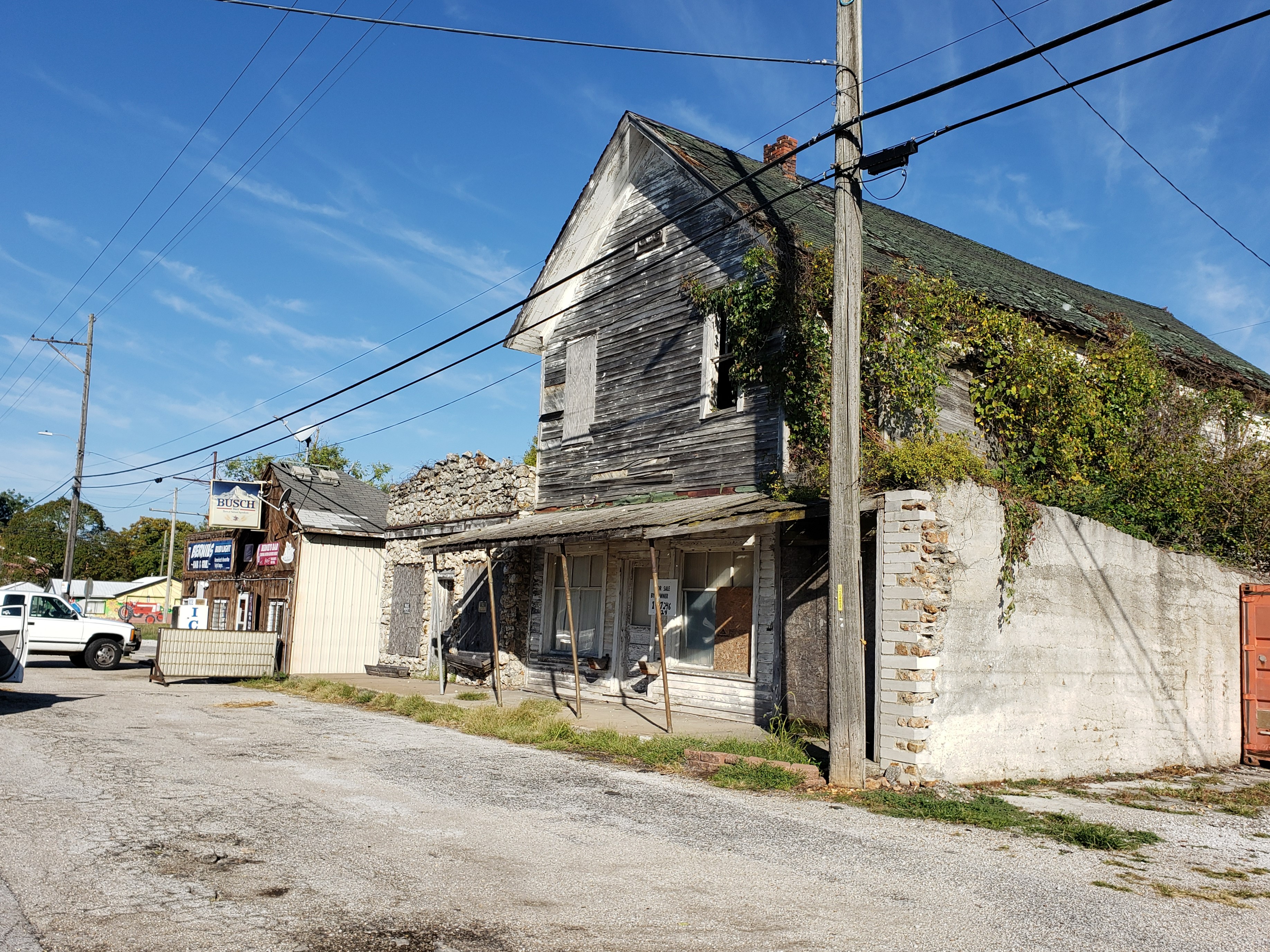
In about a mile we saw the old Red Rock Apartments.

Former Red Rock Apartments in Carthage, Missouri

This was once White’s Court, built in the 1930s. There were signs of construction when we visited. It looked like the buildings were being enlarged into bigger apartments.

Just past the Red Rock Apartments, the 1926-1953 alignment of Route 66 turns left onto Esterly Drive. Esterly drive passes Kellogg Lake.

Kellogg Lake near Carthage, Missouri (from mdc.mo.gov)

It’s easy to see why this was a popular stop and destination for Route 66 travelers.

Esterly Drive deadends at Spring River—the bridge that once crossed the river is gone—so we backtracked to Old 66 Boulevard and continued to the intersection with MO 96, which is the newer Route 66 alignment through Carthage. There are several vintage motels at this intersection from the days when Kellogg Lake was a vacation destination.

We continued west on MO 96, which becomes West Central Avenue. Route 66 turns left (south) on Garrison Avenue. Just south of this intersection is a Route 66 treasure: the 1939 Boots Court Motel.

Boots Court in Carthage, Missouri

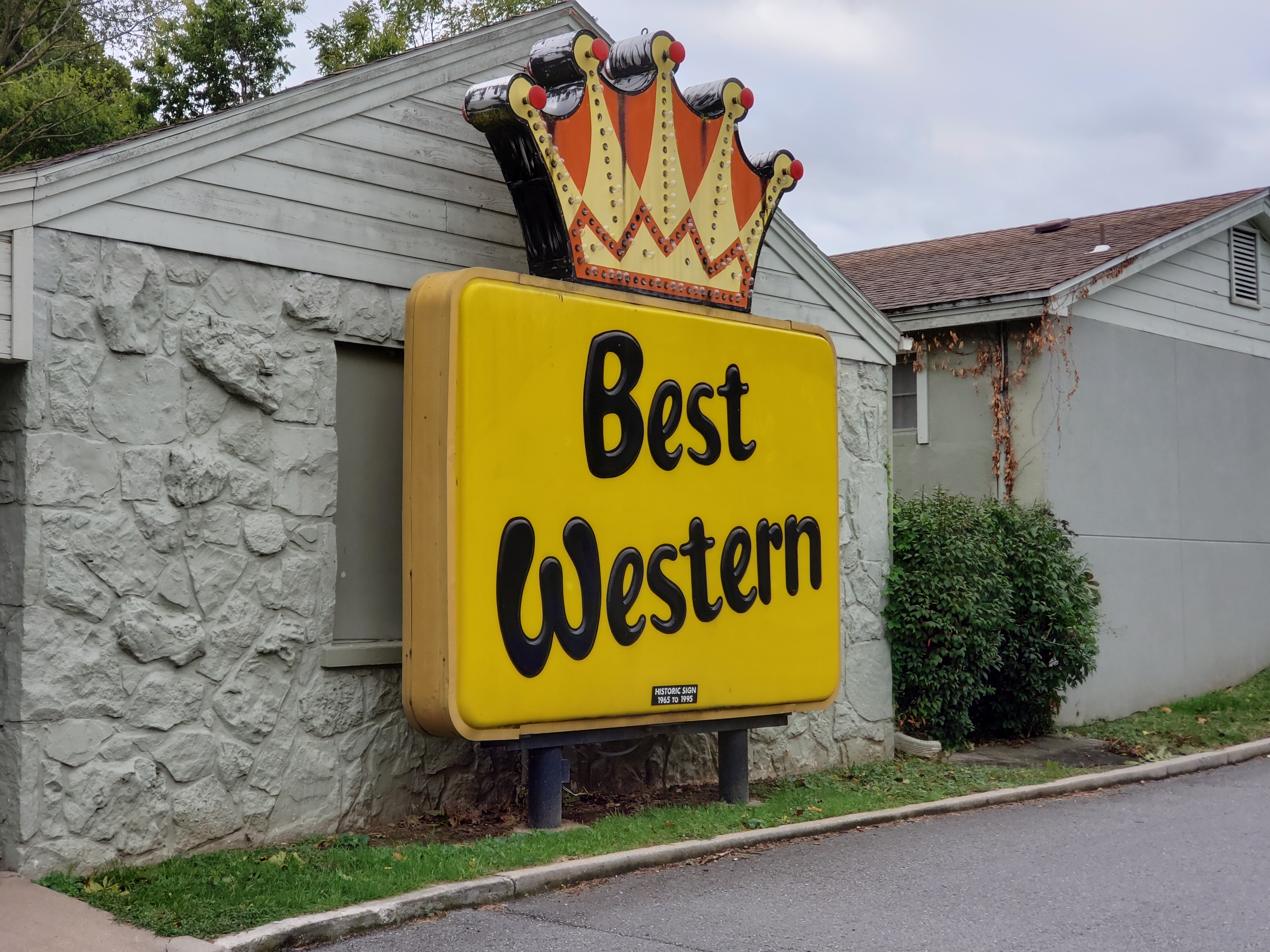
It was built in 1939, and I’ve heard that it’s the only Streamline Moderne motel along Route 66. The original neon sign is still out front.

Boots Court sign

Boots Court has two buildings. The front building, built in 1939, has carports between the rooms. The rear building, added in 1946, has garages underneath the rooms.

Boots Court 1939 building with carports in front, and 1946 building in rear

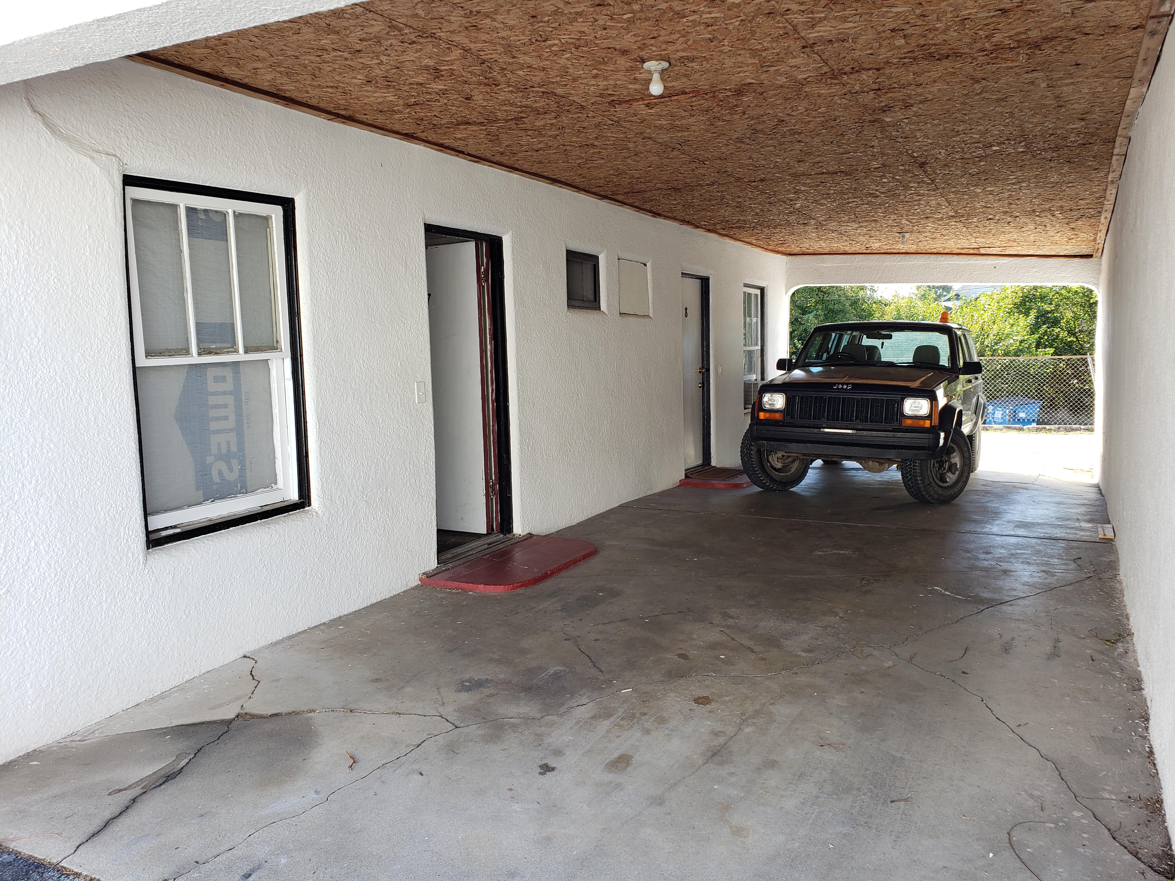
Close-up of one of the carports in the 1939 Boots Court building

While I was wandering around, I met and chatted with a man painting the trim. How I wish I’d gotten his name! He explained that the motel was recently sold and he was associated with the group that bought it. He told me that it would be closing it over Winter 2021-2022 for renovations, with reopening planned for Spring 2022. (We visited in October 2021.) I later saw articles on their plans here and here.

He showed me the room that Clark Gable stayed in!

Clark Gable stayed in this room at the Boots Court!

The man I spoke with said plans are to restore the motel with its original features, which means radios in every room but no televisions, for example. (UPDATE 11/2022: The Boots Court has been restored! See this article in Route magazine. for more information.)

Across the street from the Boots Court is a bank that was once the Boots Drive In.

An old photo of the former Boots Drive In, now a bank (from Facebook)

The man I spoke with said that the group that bought the Boots Court would eventually like to buy the bank building and restore the Boots Drive In.

We were enchanted with Boots Court and want to stay here when we return to Carthage.

We next saw the Jasper County Courthouse a few blocks away.

Jasper County Courthouse in Carthage, Missouri

The courthouse was built in 1895 in Romanesque Revival style.

We headed out of town on Oak Street, which is Route 66. In a few blocks we crossed a bridge over railroad tracks. The bridge is a bit more peaked at the top than it should be and, when you drive over it at a reasonably fast speed, you’ll understand why it’s called the Whee Bridge.

On the western edge of Carthage, Route 66 forks left off Oak Street. About a mile later is another Route 66 gem: the 1949 66 Drive In Theatre.

66 Drive-In in Carthage, Missouri

The 66 Drive In is on the National Register of Historic Places. Note the cool neon sign and the art deco ticket booth.

About a mile after the 66 Drive In, Route 66 turns right, crosses MO 171, then turns left (west). In about 2 more miles, it turns left (south) on North Pine Street into Carterville. In the center of Carterville, turn right (west) on Main Street to stay on Route 66. Continue about a mile into Webb City, Missouri, where Main Street becomes East Broadway.

In the middle of Webb City, at 112 West Broadway at the corner of North Webb Street, a 1950s gas station has been converted into a visitors center.

Former 1950s service station in Webb City, Missouri, now a visitors center

Here Broadway—and Route 66—dogleg, going a block south on Webb Street and then right (west) again. But we took a quick detour to the intersection of North Liberty and West Daugherty Streets. On the northeast corner is a former gas station.

Former post office gas station in Webb City, Missouri

This little gas station, across the street from the Webb City post office, was built in the 1920s to serve post office vehicles. I’ve read that Webb City’s post office was the only one to have its own gas station.

Route 66 had three different “alignments” between Webb City and Joplin. We chose to take the 1937-1945 alignment, so we stayed on Broadway, which becomes Powell Drive. At the end of Powell Drive, we turned right (west) on MO 171, which becomes MacArthur Drive. In about a mile, the 1937-1945 alignment of Route 66 turns left (south) on North Main Street Road.

On the northwest corner of North Main Street Road and Fountain Road are a 1930s Phillips 66 gas station and garage.

Former 1930s Phillips 66 gas station and garage north of Joplin, Missouri (from Google Maps)

On the southeast corner of North Main Street Road and Fountain Road is the 1946 Westport Inn motor court.

1946 Westport Inn north of Joplin, Missouri (from Google Maps)

We then continued south into Joplin’s historic district, centered at the intersection of Main and 5th Streets. Past 6th Street, on the left, is a small Route 66 Mural Park with two large tile murals.

Route 66 Mural Park in Joplin, Missouri (from VisitJoplinMO.com)

At the next intersection, turn right (west) on MO 66 to continue into Kansas.

Sunday, April 10, 2022

Missouri's Western Highlands: Plano, Halltown, Paris Springs, Spencer, and Avilla

West of Springfield, Missouri, Route 66 follows MO 266, also shown on Google Maps as Old Highway 66. The drive along here is pretty, with a mix of trees and fields. In about 12 miles, we reached Plano, Missouri, at the intersection of MO 266 and South Farm Road 45. It’s a ghost town with just two buildings left. On the northwest corner of the intersection are the ruins of a general store built in 1902.

Former general store in Plano, Missouri

On the southeast corner of the intersection is a former gas station and grocery store, now a private home.

Former gas station and grocery store in Plano, Missouri

About 4 miles past Plano is Halltown, Missouri, with several interesting buildings built in the early 1900s. Sadly, most are now sitting empty.

On the northeast corner of MO 266 and North Park Drive is the former Whitehall Mercantile, built in 1900 with an enormous false front.

Former Whitehall Mercantile in Halltown, Missouri (from theroute-66.com)

Whitehall Mercantile was also once the local lodge of the International Order of Odd Fellows (IOOF).

Just a couple of doors down, across the street, is the 1930 Las Vegas Hotel.

Former Las Vegas Hotel in Halltown, Missouri

It had a restaurant on the ground floor and hotel rooms on the second floor. The curved roof line means its style is Mission Revival or Spanish Colonial Revival. The small building on the right was once a barber shop.

A couple of blocks further down, at 320 West Main Street, is a 1907 stone building that was once a movie theater.

Former movie theater in Halltown, Missouri (from theroute-66.com)

About 3 miles further down MO 266, just before the intersection with Lawrence 1210, is the recreated 1930s Gay Parita Sinclair Station in Paris Springs, Missouri.

Recreated Gay Parita Sinclair station in Paris Springs, Missouri

The original gas station was built in the 1930s. It burned down in 1955, and this is a recreation of it. The adjacent 1926 cobblestone garage is original.

1926 Gay Parita garage in Paris Springs, Missouri

After Gay Parita’s gas station, MO 266 bends southwest and crosses MO 96. MO 96 is labeled US Route 66 on Google Maps, but we wanted to drive an earlier alignment. So we stayed on MO 266, crossing MO 96, then took the next right onto Lawrence 2062, shown on some maps as Farm Road 2062 or County Road 2062. We crossed Johnson Creek Bridge, a 1923 one-lane steel truss bridge.


1923 Johnson Creek Bridge (from bridgehunter.com)

Just a few hundred feet past the bridge, on the right, is a Route 66 gem: 1925 Spencer Gas Station in Spencer, Missouri.

Spencer gas station in Spencer, Missouri

We continued on Lawrence 2062 to rejoin MO 96 and continue west. In about 24 miles, we reached Avilla, Missouri. Avilla has a strip of interesting old buildings along Route 66.

Former Odd Fellows lodge in Avilla, Missouri

The large building here is the former lodge of the International Order of Odd Fellows (IOOF), built in 1885. The small gray stone building to the left of it was once a grocery store.

From Avilla we continued about 10 more miles along Route 66 to one of our favorite Route 66 towns: Carthage, Missouri.

Monday, April 4, 2022

Springfield, Missouri

Springfield, Missouri, is considered the birthplace of Route 66, because it was here that its route number was conceived. The group of business leaders who proposed a federal highway from Chicago to Los Angeles initially wanted it numbered Route 60. But another group wanted Route 60 for a transcontinental highway starting in Virginia Beach. At a meeting in Springfield, Missouri, the Chicago-to-Los-Angeles group sent a telegram to Washington suggesting Route 66 as an alternative. Their proposal was accepted, and Route 66 was born.

Route 60, as it happens, initially ended in Springfield, Missouri, and continues to run through there today.

Springfield, Missouri, once had two different Route 66s at the same time. The original 1926 alignment goes through the middle of town. When traffic became too heavy by 1936, a second Route 66 bypassing the downtown area was designated. So starting in 1936 there were two Route 66s through Springfield: “City 66” and “Bypass 66.”

We entered Springfield on MO 744, which becomes Kearney Street and Bypass 66. We passed the great neon sign of the Rest Haven Court.

Rest Haven Court in Springfield, Missouri (from DrivingRoute66.com)

But we decided City 66 would be more interesting, so we turned onto it by making a left on Glenstone Avenue. There are a lot of old motels along here including the Best Western Route 66 Rail Haven at 203 South Glenstone Avenue, where we spent the night.

Current sign at Best Western Rail Haven in Springfield, Missouri

The Rail Haven opened here in 1938, but the original buildings are mostly gone. There’s still a lot of history here. City 66 turns right (west) here on East Saint Louis Street, and the sign directing travelers has been restored.

Springfield, Missouri, directional sign at Best Western Rail Haven

The original Rail Haven neon sign has been replicated and erected along East Saint Louis Street.

Reproduction of the Rail Haven's original neon sign

As Best Western has updated its signage, the Rail Haven kept the older signs.

An old Best Western sign at the Rail Haven

Another old Best Western sign at the Rail Haven

Another old sign has been preserved.

Another old Rail Haven sign

The next morning we continued on Saint Louis Street, which is City 66. We passed one of the oldest Steak n Shakes still operating at 1158 East Saint Louis Street.

Steak n Shake on East Saint Louis Street in Springfield, Missouri (from Waymarking.com)

As City 66 approaches Park Central Square in the center of Springfield, East Saint Louis Street becomes Park Central East. Here is the Gillioz Theatre at 325 Park Central East.

1926 Gillioz Theatre in Springfield, Missouri (from nps.gov)

The theatre opened in 1926. Its style is called Spanish Colonial Revival.

Past Park Central Square, City 66 becomes Park Central West and then West College Street. Here are three old motels built of local Ozark “giraffe” stone.

The adorable 1920 (hey, that's really old!) Rockwood Motor Court is at 2200 West College Street.

1920 Rockwood Motor Court in Springfield, Missouri (from RockwoodCourt.com)

The rooms have been recently restored. We’d love to stay there the next time we visit Springfield, Missouri.

Further down the block, at 2238 West College Street, is the 1935 Shamrock Court Motel with its original sign.

1935 Shamrock Court in Springfield, Missouri (from TheAlternativeTourist.com)

And on the next block is the 1945 Rock Fountain Court at 2400 West College Street.

1945 Rock Fountain Court in Springfield, Missouri (from Waymarking.com)

A few blocks later, City Route 66 merges into Bypass 66, and Route 66 leaves Springfield, Missouri, on the West Chestnut Expressway (MO 266). We were on our way to several more Missouri towns along Route 66, starting with Plano