Wednesday, July 20, 2022

Warwick, Luther, and Arcadia, Oklahoma

We think Warwick, Luther, and Arcadia, Oklahoma, have some of the most interesting stops along Route 66 in Oklahoma. Our first stop along this stretch of Route 66 was the Seaba Station  in Warwick, Oklahoma.

Seaba Station in Warwick, Oklahoma

The distinctively-styled Seaba Station was built in 1921 or 1924 (sources give varying dates). This makes it one of the oldest gas stations on Route 66 offering full automobile service, not just gas. 

Today the station houses the Seaba Station Motorcycle Museum and a gift shop. The museum is free but donations are appreciated. It’s an impressive collection.

Behind the Seaba Station are the preserved remains of its outhouse, also built in the 1920s.

Seaba Station outhouse

The interior looks like it was surprisingly nice for its time.

Seaba Station outhouse interior

(Yes, there's a part of me that can't believe I'm posting photos of an outhouse interior on a public blog!) 

From Warwick, Oklahoma, we continued about 2 miles on OK 66. Just after crossing I-44, we forked right (northwest) on an earlier “alignment” of Route 66: OK 66B into Wellston, Oklahoma. OK 66B turns left (west) on 2nd Street, then rejoins the newer alignment (OK 66).

About 2½ miles later, on the eastern outskirts of Luther, Oklahoma, we reached what we think is one of the most historically important stops on Route 66: the Threatt Filling Station (pronounced "Treat") on the southwest corner of OK 66 and Pottawatomi Road.

Threatt Filling Station in Luther, Oklahoma, in April 2022

If travel on early Route 66 was hard for so many people, it was especially hard for African Americans. Many places along Route 66 refused to serve them, and many towns along Route 66 were “sundown towns” where African Americans couldn’t stay past sundown.

Allen Threatt, Sr., an African American, owned a farm outside Luther. In 1915 he decided to build a gas station on the edge of his property that bordered what was then OK 7. Until the 1950s, the Threatt Station was one of the few places along Route 66 where African Americans were welcome. The Threatts added groceries and a café, allowed African American travelers to camp overnight on their farm, and hosted weekend dances and Negro baseball league games.

We were glad to see the Threatt Station under restoration when we visited. We’re looking forward to visiting it when it reopens.

Another view of the Threatt Station being rehabilitiated in April 2022

West of Luther are the remains of another old stone gas station.

Remains of an old gas station west of Luther, Oklahoma

This gas station is about half a mile west of North Choctaw Road, on the north side of Route 66. I couldn't find out much about its history. Someone on Facebook shared this article that confirms how little is known about it.

About a mile past those ruins, OK 66 curves to the northwest. We forked left onto an early “alignment” of Route 66 built in 1928-1929. This segment was paved in two ways. As the photo below shows, the eastern half was paved in concrete in 1928.

Looking west from OK 66 at the eastern end of a 1928-29 segment of Route 66 east of Arcadia, Oklahoma

(This is one of our favorite photos of our Route 66 road trips to date. For us, it captures the fun and excitement of our Route 66 road trip: a historic, off-the-beaten-path road with unknown experiences off in the distance.)

The western half of this segment was paved in 1929 using an experimental approach of macadam over concrete with curbs.

Western half of a 1928-1929 segment of Route 66 east of Arcadia, Oklahoma

Along the western half of the road is a sign commemorating Paul McCartney driving Route 66 when he was…66 years old.

Sign commemorating Paul McCartney's Route 66 road trip east of Arcadia, Oklahoma

Just before this old segment merges back into OK 66, look on the right for an old cottage-style Phillips 66 station that’s now part of a house.

Former Phillips 66 station converted into a private home east of Arcadia, Oklahoma (from Google Maps)

We loved driving this old stretch of Route 66. It’s another one of those stretches where you feel you’re going back in time and getting a sense of what it was like to drive cross country 100 years ago.

About a mile after rejoining OK 66 is another Route 66 icon: the Round Barn at 107 OK 66 in Arcadia. 

Round Barn in Arcadia, Oklahoma

The Round Barn was built in 1898 under the theory that a round barn might be less susceptible to tornadoes. Today it houses a gift shop.

About a quarter mile past the Round Barn is yet another famous stop on Route 66: Pops 66 Soda Ranch at 660 Route 66 in Arcadia, Oklahoma.
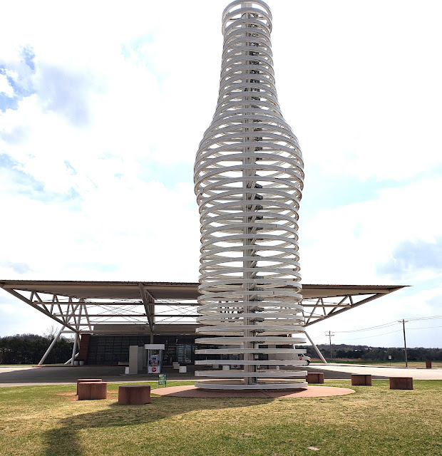
Pops 66 Soda Ranch in Arcadia, Oklahoma

We stopped here for lunch, and we were glad to did! The classic diner food was great, the service friendly, and the interior bright and sparkling clean. 

Interior of Pops 66 Soda Ranch in Arcadia, Oklahoma

And of course there are 500 soda flavors to choose from! They’re helpfully grouped by flavor. (The ones by the windows are for display; the ones to choose from are in refrigerated cases.)

After Pops, we continued about 4 or 5 miles on OK 66 to I-35, where Route 66 becomes US 77. Then it was another 3 miles into Edmond, Oklahoma. US 77 turns left (south) in the middle of Edmond. It becomes I-235, which continues into Oklahoma City.

Saturday, July 9, 2022

Depew, Stroud, Davenport, and Chandler, Oklahoma...and the Ozark Trail Highway

We enjoyed this stretch of Route 66 even more than we thought we would. There are a lot of underappreciated sights along here.

From Bristow, Oklahoma, we continued west on Route 66 (OK 66) to Depew, which is a Route 66 oddity. The original road ran north of town, where it does today. But the road wasn’t yet paved, so Route 66 initially made a loop into Depew to take advantage of its paved roads. The road was paved, and Depew bypassed, in 1928—only two years after Route 66 was established.

To follow the original Route 66, we turned left (south) onto Flynn Avenue and right (west) on Main Street. On the southwest corner of Main Street and Malley Avenue is the former Hicks Filling Station, built around 1920.

1920 Hicks Filling Station in Depew, Oklahoma

We continued another two blocks on Main Street, then turned right (north) on Ladd Avenue to return to OK 66.

Over the next 10 miles we saw fragments of earlier alignments of Route 66 along both sides of OK 66. We soon entered Stroud, Oklahoma, and within a few blocks saw a Route 66 icon: the Rock Café at 114 West Main Street. 

1939 Rock Cafe in Stroud, Oklahoma

The Rock Café and its famous neon sign were built in 1939. The restaurant is on the National Register of Historic Places and has been featured on the Food Network’s Diners, Drive Ins, and Dives. It burned in 2008 but has been beautifully restored.

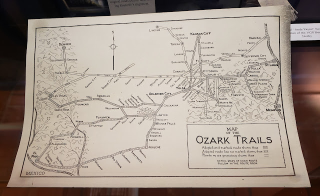
Our next goal after Stroud was to travel a segment of a road older than Route 66: the Ozark Trail Highway. Before Route 66 and other Federal highways were established in 1926, business leaders took it upon themselves to create cross-country highways. One of the most famous of these early highways was the Lincoln Highway, which crossed the country and intersected with Route 66 in Joliet, Illinois.  The Ozark Trail Highway, from St. Louis, Missouri, to Las Vegas, New Mexico, was established in 1915. It was more a network than a highway, as this old map in the Oklahoma Route 66 Museum shows.

Ozark Trails Map

When Route 66 was established in 1926, it followed much of the Ozark Trail Highway. One segment of the original Ozark Trail Highway is southwest of Stroud. It was constructed in 1915-17 and is still in original condition: dirt. (Not a good idea to drive this if it’s been raining recently!)

To follow the original Ozark Trail Highway segment, we drove south from Stroud on OK 99. In about a quarter mile, we turned right (west) on West Central Street. When West Central Street ended in about a mile, we turned left (south) on Old Stroud Road. In about a mile, we turned right (west) on E0880 Road (also known as 26th Street). When E0880 Road ended in about a mile, we turned left (south) on Ozark Trail Road. In another mile, we reached our goal: an obelisk at the intersection with East 890 Road.

Ozark Trail obelisk west of Stroud, Oklahoma

Many of the very early highways were marked with painted posts. The Lincoln Highway, for example, was marked with posts painted red, white and blue, and at first the Ozark Trail Highway was marked with posts painted green and white. But the Ozark Trail Highway was soon marked with obelisks, and this is one of the few remaining today. Until recently it was covered with graffiti, but it’s been nicely cleaned up.

At the obelisk, we turned right (west) on East 890 Road to rejoin OK 66 in about two miles. You can see the dirt road in the photo above.

We loved taking this stretch of road. It gave us a feel for what it was like to cross the country over a hundred years ago, before many roads were paved. If you look closely as you drive along it, you’ll see a few concrete culverts and box drains that were built in 1915-1917, when the road was constructed.

Back on OK 66, we continued a mile and a half into Davenport, Oklahoma. Just before reaching downtown, Route 66 (OK 66) bends right, and here is a former 1933 Texaco station. For a while it was reopened as the Early Bird Diner, but that's now closed.

1933 Texaco station in Davenport, Oklahoma

Instead of bending right at the Texaco station to continue on Route 66, we took a short detour. We continued straight for two blocks south on Broadway and found a treasure: several blocks of Broadway paved in brick in 1925-1926.

Broadway in Davenport, Oklahoma

This stretch on Broadway is on the National Register of Historic Places. There are some murals here too!

We then returned to the Texaco station to continue on Route 66 (OK 66) to Chandler, Oklahoma. On the outskirts of Chandler, we had a fun stop at the Route 66 Bowl.

Sign for the Route 66 Bowl in Chandler, Oklahoma, plus vintage gas station signs

Route 66 Bowl in Chandler, Oklahoma, with more vintage gas station signs

As you can see, the Route 66 Bowl has a great neon sign and a wonderful collection of vintage gas station signs. We’re old enough that many of those signs brought back memories!

OK 66 curves left (south) in front of the 1937 Chandler Armory, now the Route 66 Interpretive Center.  OK 66 then merges into Manvel Avenue. There are a lot of historic buildings along here, including 12 on the National Register of Historic Places. A month after our visit, I saw this map of Chandler’s historic sites on Facebook. 

Map of historic sites in Chandler, Oklahoma (from Facebook)

On our next drive through here, we want to stop and explore more of Chandler--there's a lot to see and do here!

On this trip, we stopped at just one historic site: a 1930 Phillips 66 gas station at 701 Manvel Avenue.

1930 Phillips 66 gas station in Chandler, Oklahoma 

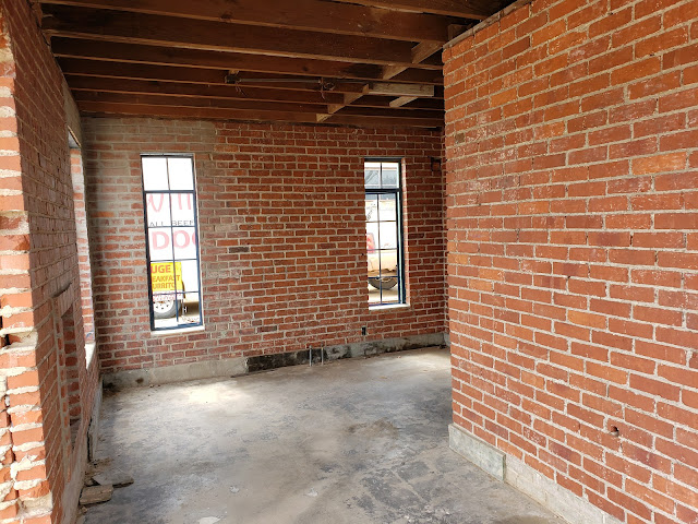
This Phillips 66 station has been restored on the exterior, but the interior remains gutted and open. So this was a rare chance to get a sense of what these stations looked like inside. They were definitely as small inside as they look on the outside!

Interior of Phillips 66 station in Chandler, Oklahoma

One rest room was inside.

Interior rest room (on left) in Phillips 66 station in Chandler, Oklahoma

Another rest room had an outside entrance.

Exterior rest room in Phillips 66 station in Chandler, Oklahoma

At the southern end of Chandler, Route 66 (OK 66) turns right (west) on West 15th Street. From here it was about 6 miles to Warwick, Oklahoma.