Friday, August 26, 2022

Bridgeport to Clinton, Oklahoma

We loved Route 66 between Bridgeport and Clinton, Oklahoma. We saw one of the best Route 66 museums in the country, one of the best bridges on Route 66, some great old service stations, and a beautiful art deco neon sign, among other things.

We left Geary, Oklahoma, on US 281. US 281 was never Route 66, which ran a bit west of here on roads that are now back roads. About three miles south of Geary, US 281 turns off to the right (southwest), while Business US 281 continues straight. We stayed on Business US 281 another mile or so. Then we turned right (west) on what Google Maps calls Old US Highway 66.

In 1931, work began on a new Route 66 running straight from El Reno to Hydro, bypassing Geary. The new road was finished in 1934. This stretch of “Old US Highway 66” is part of that original 1934 road. On the right is the 1934 Bridgeport Hill Service Station, clearly built to capitalize on the new road.

1934 Bridgeport Hill Service Station in Bridgeport, Oklahoma

Just before the intersection of Old US Highway 66 and US 281, there’s a little road on the left that leads to US 281 a bit south of the intersection. This tiny arc is also part of the original 1934 Route 66.

We took US 281 south to follow the 1934 Route 66. In about one mile, we reached an engineering marvel: the bridge over the South Canadian River.

William H. Murray Bridge, also known as Canadian River Bridge and Pony Bridge, in Hinton, Oklahoma

I’ve seen this bridge called the Canadian River Bridge, the William H. Murray Bridge, and simply the Pony Bridge. Each of those humps is called a truss. This truss bridge is an example of a pony bridge, which means the trusses are not connected over the top of the road.

When this Pony Bridge was completed in 1933 or 1934 (sources give varying dates), it was considered an engineering marvel. Ninety years later, it’s still truly impressive. Look how you can't even see its end! It is the longest truss bridge on Route 66. A scene in The Grapes of Wrath was filmed at the west end.

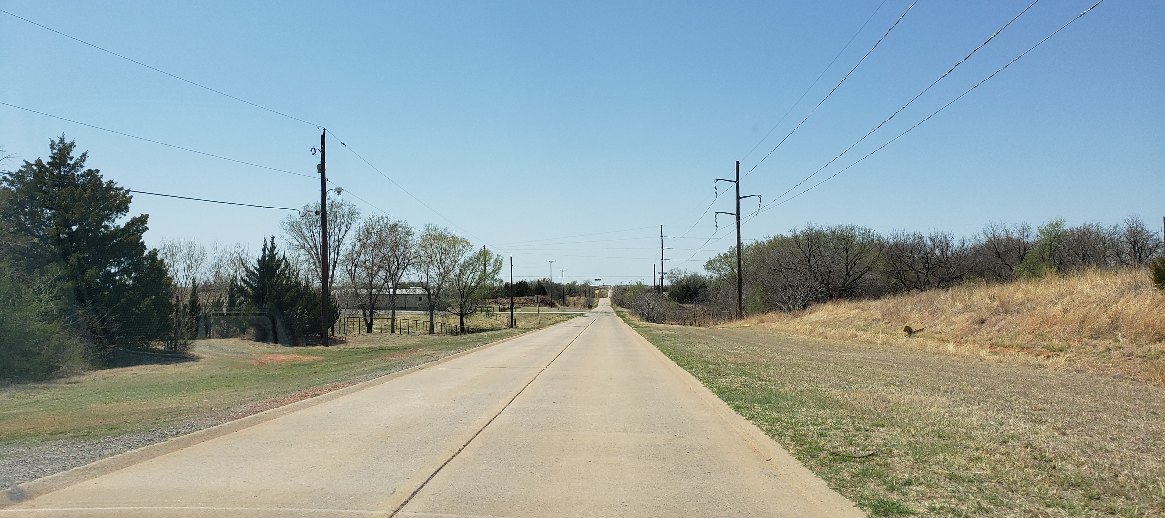
About a mile past the Pony Bridge, US 281 bends left (south), but Route 66 continues straight west. This stretch from Bridgeport to Hydro was built between 1931 and 1934, and it was innovative for its time. The road bed is 20 feet wide instead of the then-standard 18 feet. The road also has drainage features. One was called a “parabolic crown,” which means the road tapers off on each side from the dividing line in the center to help rain run off.

This stretch of Route 66 is beautiful, with broad vistas.

Route 66 near Hinton, Oklahoma
Another view of Route 66 near Hinton, Oklahoma

Near Hydro, Route 66 runs alongside I-40.

Route 66 near Hydro, Oklahoma

Here is a Route 66 treasure: the Provine Service Station , also known as Lucille’s Historic Highway Gas Station or simply Lucille’s Place.

Provine Service Station, also known as Lucille's Place

The complex also includes a small motel. The complex is now a museum and was not open when we visited.

Lucille's Motel

Lucille’s Service Station was built in 1929. In 1934, it was sold and renamed the Provine Service Station. In 1941, the Hamons family took it over. Lucille Hamons ran it for almost 60 years. Her generosity to travelers earned her the title “Mother of the Mother Road.”

About two miles past Lucille’s, just past North 2440 Road on the left, is a railroad trestle built in 1931.

1931 railroad trestle east of Weatherford, Oklahoma

And about a mile past the railroad trestle, on the outskirts of Weatherford, Oklahoma, is Lucille’s Roadhouse, a restaurant that’s a delightful tribute to Lucille Hamons.

Lucille's Roadhouse in Weatherford, Oklahoma

We had a really nice lunch here—good food and service. It’s not a historic building but has a great retro vibe. Part of the restaurant looks like a diner, and the other part looks like an old-fashioned steakhouse. I think they both serve the same menu.

After Lucille’s Roadhouse, Route 66 becomes Weatherford's East Main Street. In about half a mile, we turned left to stay on East Main Street. At the west end of Weatherford, we turned left (south) on OK 54 (South 4th Street) to stay on Route 66.  OK 54 soon runs along the north side of I-40. About 5 or 6 miles past Weatherford, Route 66 does a little dogleg, making a quick right (north) on North 2330 Road, then an immediate left (west) on East 1030 Road. In about a mile and a half, we turned left (south) on North 2310 Road.

At the I-40 interchange is the massive, family-owned Cherokee Trading Post and Boot Outlet

Cherokee Trading Post near Clinton, Oklahoma (from OnlyInYourState.com)

Here we took the frontage road/service road on the north side of I-40 toward Clinton, Oklahoma. It merges into Business I-40 on the outskirts of Clinton. In about a mile, on the left, is the Mohawk Lodge Indian Store.

Mohawk Lodge Indian Store (from Facebook)

The store’s roots go back to the 1890s. It was moved here in 1940 and it still sells genuine Native American crafts.

After the Mohawk Lodge Indian Store, Business I-40 becomes Choctaw Avenue and then West Gary Boulevard. We turned left (south) on 10th Street to stay on Route 66. In less than a mile, just past Knox Avenue, we reached the stunning entrance to McLain Rogers Park.

Entrance to McLain Rogers Park in Clinton, Oklahoma

The park, including this sign, was built in 1934-1937 by the Works Project Administration. The beautifully preserved neon sign is in the “zigzag” art deco style popular at the time. (See my post on Tulsa’s art deco architecture for more information on art deco and zigzag.)

Just past the park, we took a quick detour off Route 66, turning right (west) on Jaycee Lane and another right (north) on West Gary Boulevard. On the west side of West Gary Boulevard is the Oklahoma Route 66 Museum.

Oklahoma Route 66 Museum in Clinton, Oklahoma

I had read that the Oklahoma Route 66 Museum may be the best of the many Route 66 museums. We haven’t visited every one, so I can’t confirm that, but this was by far the best one we’ve visited. Many Route 66 museums are collections of Route 66 artifacts. This one tells the story of Route 66 in a series of exhibits in chronological order. Of course Oklahoma’s role in Route 66 is highlighted! We learned so much. If you visit only one Route 66 museum, consider making it this one.

After the museum, we returned to Route 66 (South 10th Street) and continued south out of Clinton. South 10th Street becomes Neptune Drive. About half a mile past I-40, Route 66 (Neptune Drive) bends to the right (west). At this fork in the road is the former Y Service Station and Cafe .

Former Y Service Station in Clinton, Oklahoma

The Y Service Station was built in 1937. Its style is Southwestern Mission Revival—unusual for this part of the country.

After the Y Service Station, Route 66 becomes West Commerce Road. This was Route 66 between 1931 and 1956, and it still has the original Portland concrete.

Route 66 west of Clinton, Oklahoma

West Commerce Road becomes I-40’s South Frontage Road. Here you can compare undulating Route 66 with the flattened-out interstate.

Route 66 further west of Clinton, Oklahoma, running south of I-40

We were on our way to our next overnight stop in Elk City,Oklahoma.

Monday, August 15, 2022

El Reno and Geary, Oklahoma

We’ve come to appreciate towns along Route 66 that make a real effort to capitalize on their location along Route 66 and try to attract visitors. Two of those towns are El Reno and Geary, Oklahoma. Special props go to Geary, which is on a very old Route 66 “alignment” and probably skipped by a lot of Route 66 travelers.

After seeing Lake Overholser Bridge on our way out of Oklahoma City, we continued west on Route 66 (OK 66). In about 16 miles, Route 66 bends to the right (northwest) into El Reno, Oklahoma.

Between Jenkins and Cooney Streets, we found a Route 66 oddity. In 1936, Route 66 traffic was so bad here that an underpass was built so students could get to school. The two underpass entrances are still there, though they’ve been sealed off. This is the west entrance.

West entrance to Route 66 pedestrian underpass in El Reno, Oklahoma

And this is the east entrance:

East entrance to Route 66 pedestrian underpass in El Reno, Oklahoma

Three blocks later, we reached downtown El Reno.

Downtown El Reno, Oklahoma

Here we turned left (west) on Wade Street and went two blocks to Choctaw Street. This intersection is the epicenter of El Reno’s Route 66 sights! On the southeast corner is the former 1934 Jackson’s Conoco, now Lee Donut.

1934 Jackson's Conoco in El Reno, Oklahoma

On the northwest corner is the former 1933-1934 Avant Cities Service, now a rental center.

1933-1934 Avant Cities Service Station in El Reno, Oklahoma

If you look past the paint, you can see beautiful art deco details in the Avant Cities Service station.

Close-up of some of the art deco details of Avant Cities Service 

On the northeast corner is a great Route 66 sign.

Route 66 sign in El Reno

On the left is a map of Oklahoma, with plenty of padlocks attached by visitors.

Route 66 does a dogleg here, turning right (north) on Choctaw, then left (west) on Sunset Drive (Business I-40). On the right side of Sunset Drive is a mural and a 1950s gas station.

Mural on Sunset Drive in El Reno

On the left side of Sunset Drive, a chicken from the old Squawk & Skoot restaurant is still sticking out of a wall.

Squawk 'n' Skoot sign in El Reno (from waymarking.com)

Sunset Drive is Route 66, OK 66 and Business I-40. We continued west on Route 66 for about three miles. When Business I-40 bent southwest, we turned right onto E 1020 Road. This is the 1926 “alignment” of Route 66. (Signs for Fort Reno will tell you you’re on the right road.)

In about 3 or 4 miles, we turned right (north) on US 270 to continue on the 1926 alignment. (If you stay straight on OK 66, you’re on the alignment built in 1931-1934. In about 4 or 5 miles, US 270 reaches Calumet, Oklahoma, and turns left (northwest). About 11 miles past Calumet, it arrives in Geary, Oklahoma, as Southeast South Street.

We turned right (north) on Broadway. On the southeast corner of Broadway and Main is the Canadian River Historical Museum housed in the 1903 Gillespie Building. On the northeast corner of Broadway and Main is a Rock Island Railroad caboose and a “hoosegow”: Geary’s jail from 1893 to 1909.

1893 Hoosegow in Geary, Oklahoma

We turned right (east) on Main Street and went one block to Canadian Avenue. On the northeast corner of this intersection is a public water trough, used in the early 1900s.

Public Water Trough in Geary, Oklahoma

We headed back south on Broadway, which becomes US 281. This would take us back to the 1931-1934 “alignment” of Route 66 and one of Route 66’s iconic sights: the huge Pony Bridge over the South Canadian River.

Friday, August 5, 2022

Oklahoma City

We really enjoyed our visit to Oklahoma City. In addition to the Route 66 sights OKC is known for, we stumbled onto an amazing neighborhood full of beautiful historic homes.

We drove into Oklahoma City in late afternoon, so we started our visit by checking into the Skirvin Hilton at 1 Park Avenue.

1911 Skirvin Hilton in Oklahoma City

The Skirvin was built in 1911 and has been beautifully restored. We chose it because it’s within walking distance of both the Oklahoma City National Memorial and Bricktown.

And we indeed walked to Bricktown, a former warehouse district that now has restaurants and entertainment. We had a fun dinner at Bricktown Brewery at 1 North Oklahoma Avenue.

Sign at the Bricktown Brewery in Oklahoma City

The next morning we had a great breakfast in the beautiful Craftsman-style restaurant at the Skirvin.

Restaurant at the Skirvin Hilton in Oklahoma City

Check the tiles on the columns!

Unfortunately, it was raining, so we didn’t walk to the Oklahoma City National Memorial as we had planned. Instead, it was our first stop on a driving tour of Oklahoma City.

Oklahoma City National Memorial

In the distance, you can see chairs representing everyone who died.

Mementoes left by memorial visitors

We then took North Hudson Avenue north to rejoin Route 66 (Northwest 23rd Street)…and found ourselves driving through a neighborhood of magnificent mansions. We later learned that this part of Oklahoma City is called Heritage Hills. The homes here were largely built between 1905 and 1930. One of the ones that blew us away is the Hales Mansion at 1521 North Hudson Avenue.

1916 Hales Mansion in Oklahoma City (from JournalRecord.com)

The Hales Mansion was built in 1916 in Classical Revival style.

Another amazing mansion is the 1905 Overholser Mansion at 405 Northwest 15th Street (on the northwest corner of the intersection of Northwest 15th Street and North Hudson Avenue).

1905 Overholser Mansion in Oklahoma City (from Wikipedia)

On the northwest corner of the intersection of North Hudson Avenue and Northwest 23rd Street (Route 66), we saw a former Phillips 66 cottage-style gas station at 401 Northwest 23rd Street. It was built in 1935.

Former 1935 Phillips 66 gas station

We turned left (west) on Route 66. Just past the old Phillips 66 station is the 1937 Tower Theatre, with a great neon sign, at 425 Northwest 23rd Street.

1937 Tower Theatre in Oklahoma City (from okcfox.com)

In about 6 or 7 blocks, we saw the Gold Dome Building on the right.

1958 Gold Dome Building in Oklahoma City

The Gold Dome Building was built in 1958 as a bank. It was surrounded by a chain link fence when we visited, so we couldn’t get close.

Just past the Gold Dome Building, we turned right (north) on North Classen Boulevard to stay on Route 66. In one block, on the right is the Milk Bottle Grocery at 2426 North Classen Boulevard.

1930 Milk Bottle Grocery in Oklahoma City

This tiny building was built as a grocery store in 1930. The milk bottle on top was added in 1946. Unlike most giant roadside structures, the milk bottle wasn’t built to advertise the grocery. Instead, it was rented out to local dairies for advertising, like a billboard. Over the years it was repainted to advertise whichever dairy was paying at the moment. These days it advertises Braum’s.

Oklahoma City has had many Route 66 “alignments” over the years. We didn’t try to follow any of them heading west. Instead, we continued north on North Classen Boulevard for another mile, then turned left (west) on Northwest 36th Street. In about 3 or 4 miles, we turned right (north) on North Meridian Avenue. In a few blocks, we turned left (west) on Route 66 (OK 66). In about 4 miles, we turned left (south) on Overholser Drive. In a few hundred feet, we arrived at Lake Overholser Bridge in Bethany, Oklahoma.

1924-1925 Lake Overholser Bridge in Bethany, Oklahoma

Lake Overholser Bridge was built in 1924-1925, so it’s older than Route 66. It’s considered an especially beautiful bridge for the time. By the 1950s, the bridge was too small to accommodate Route 66 traffic, so Route 66 was rerouted to a new four-lane bridge just to the north.

After crossing Lake Overholser Bridge, we continued another half mile on Overholser Drive, then turned right (north) on North County Road to rejoin Route 66 (OK 66) and continue west to El Reno, Oklahoma.