From Baxter Springs, Kansas, Route 66 follows Alternate US 69 into Oklahoma. After Quapaw, Oklahoma, Alternate US 69 becomes "regular" US 69. At Commerce, Oklahoma, Route 66 originally turned right (west) on Commerce Avenue, then left (south) on Main Street. At the intersection of Commerce and Main are two Route 66 icons. The first is a former 1925 Marathon gas station at 100 North Main Street.
 |
| Dairy King in Commerce, Oklahoma (from Route66art.blogspot.com) |
It’s now a Dairy King ice cream stand.
Across the street at 101 North Main Street is the 1929 or 1930 Allen’s Conoco Station (sources give varying dates).
 |
| Allen's Conoco in Commerce, Oklahoma (from Route66art.blogspot.com) |
Allen’s Conoco is also known, for obvious reasons, as the Hole in the Wall Conoco Station.
Continue south on Main Street to merge back into US 69.
Within a couple of miles we were in Miami (pronounced My-AH-muh), Oklahoma. At 915 North Main Street is yet another Route 66 icon: Waylan’s Ku Ku Burger with a great neon sign…and a bird tucked under the eaves.
 |
| Waylan's Ku Ku Burger in Miami, Oklahoma (from onlyinyourstate.com) |
Waylan’s was once a chain, but now this is the only one left.
About seven blocks south of Waylan’s, at 103 North Main Street, is one of the most beautiful theaters we’ve ever seen: the 1929 Coleman Theatre.
 |
| Coleman Theatre in Miami, Oklahoma (from TripAdvisor.com) |
The Coleman Theatre’s style is called Spanish Revival.
About three blocks past the Coleman Theatre, past 2nd Avenue, is a Route 66 gateway sign over the road.
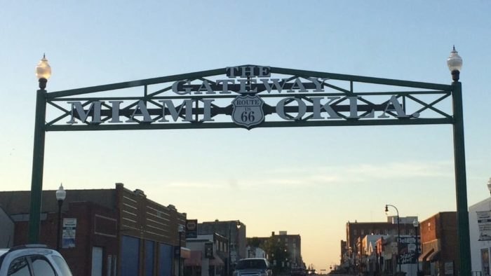 |
| Route 66 gateway sign in Miami, Oklahoma (from onlyinyourstate.com) |
It’s a 2012 replica of a sign that was here in the early 1900s, before Route 66 was born.
 |
| Early 1990s gateway sign in Miami, Oklahoma (from theroute-66.com) |
After the gateway sign, US 69 turns right (west). It’s the 1937 “alignment” of Route 66. We stayed straight on South Main Street for two special experiences on the pre-1937 alignment.
The first is a 1929 Marathon service station at 331 South Main Street.
 |
| 1931 Marathon gas station (from Wikipedia.org) |
The station is interesting because it’s in Neoclassical Revival style, a rare style for gas stations.
The next thing we wanted to experience along the pre-1937 alignment was a stretch of Route 66 that’s only 9 feet wide.
 |
| Nine-foot "ribbon road" between Miami and Narcissa, Oklahoma |
This 9-foot-wide segment is called the Ribbon Road, the Sidewalk Highway, and the Miami Nine-Foot Section. Apparently local officials only had half the concrete they needed to cover this three-mile stretch of road. Their choices were to pave only half of the stretch or to make the road only half as wide as it should be. They chose the latter. The road was paved between 1919 and 1921, before Route 66 was designated.
Some notes if you’re thinking of driving on the Ribbon Road: As you can see in the photo above, much of the Ribbon Road has been covered with gravel. That makes the road wider and more usable to local residents, but it can make the Ribbon Road hard to see. Drive slowly—if you drive quickly, gravel can fly up and chip or dent your vehicle.
A lot of people reach the Ribbon Road by taking US 69 (the newer alignment of Route 66) about 4 miles south of Miami to East 140 Road. East 140 Road is the southwest stretch of the Ribbon Road and marked with a monument.
 |
| Ribbon Road monument near Narcissa, Oklahoma |
But we wanted a fuller experience of driving the Ribbon Road, so instead of taking US 69, we continued south on Main Street from Miami. Main Street becomes E Street Southwest, which dead ends in about 3 miles at East 130 Road. Turn right (west) on East 130 Road, which soon becomes gravel. You’re on the Ribbon Road.
East 130 Road dead ends at South 540 Road. Turn left (south) on South 540 Road to continue on the Ribbon Road. At East 140 Road, turn right (west) to continue further on the Ribbon Road, which ends at US 69, where the monument is.
Route 66 continues on US 69 south. Near the I-44 interchange, just north of Afton, there’s another stretch of Ribbon Road. Before the I-44 interchange, just past the Northeast Tech Center, turn right (west) on East 200 Road. In about a mile, turn left (south) on South 520 Road. This is the second Ribbon Road. It ends at US 60. There's another marker here.
 |
| Ribbon Road monument near Afton, Oklahoma |
We then continued on US 60 through Afton to Vinita. About 3 miles before Vinita, at the intersection with S 4440 Road, we saw the 1940 McDougall filling station.
 |
| 1940 McDougall filling station near Vinita, Oklahoma (from Wikipedia.org) |
The stone is called giraffe stone for obvious reasons!
In Vinita, US 60 becomes East Illinois Avenue. Another Route 66 icon, Clanton’s Café, is at 319 East Illinois Avenue.
 |
| Clanton's Cafe in Vinita, Oklahoma (from ClantonsCafe.com) |
Clanton’s has been at this location since 1947. It’s the oldest continuously family-owned restaurant on Route 66.
A couple of blocks after Clanton’s, turn left (south) onto South Wilson Street to stay on Route 66 (US 60). About 3 or 4 miles out of Vinita, US 60 forks right. Keep straight onto OK 66 to stay on Route 66.
OK 66 passes through Chelsea and continues into Foyil. Here we detoured onto a short 1931 “alignment.” We turned left onto East 4th Street, then took a quick right (south) on Andy Payne Boulevard. This is the 1931 alignment. There's a cool 1923 or 1931 Texaco station on the left (sources give varying dates).
 |
| Texaco station in Foyil, Oklahoma |
The February/March 2022 issue of Route magazine has a great article on this old Texaco station.
After rejoining OK 66, we continued about 6 or 7 miles into Claremore. On the northern edge of Claremore, just before Will Rogers Junior High School on the left, we turned right on J. M. Davis Boulevard. This was the 1926-1958 “alignment” of Route 66. The building along here that most intrigued us was the former Public Information Building.
.png) |
| 1940 Public Information Building in Claremore, Oklahoma (from Google Maps) |
It was built in 1940. As Will Rogers’ birthplace, Claremore was already a popular tourist attraction then.
Speaking of which…we’d heard great things about the Will Rogers Memorial & Museum in Claremore. Unfortunately, when we drove through Claremore, it was late in the afternoon and, with the museum closing at 5 PM, we felt we couldn’t do it justice, so we left a visit there for another time.
J. M. Davis Boulevard rejoins OK 66 (Route 66) on the south end of Claremore. In about 8 miles, we reached our last stop before Tulsa: Catoosa. You can’t miss Catoosa’s star attraction: the Blue Whale at 2680 OK 66.
 |
| The Blue Whale of Catoosa, Oklahoma |
The Blue Whale was NOT created as a Route 66 attraction. It was built in 1972, after Route 66 was decommissioned. Hugh Davis owned this property and built the whale for his wife. It’s a great photo op and place to stretch your legs.
On the other side of OK 66 is the 1936 Arrowood Trading Post.
 |
| 1936 Arrowood Trading Post in Catoosa, Oklahoma |
This building was a true Indian trading post, originally the Chief Wolf Robe Hunt Trading Post. While you can see it from the Blue Whale and OK 66, it actually faces “Old Highway 66”: the 1920s alignment that runs parallel to OK 66 to the east.
We then left Catoosa for Tulsa, one of our favorite cities on Route 66.


.jpg)


