Dwight, Illinois, is about 9 miles down Historic US 66 from Gardner. Here Historic US 66 runs along I-55. About two miles before Gardner, Historic US 66 splits away from I-55. About a mile after that split, we turned left onto South Brewster Road, which quickly turns into Dwight Road. This is the original 1926 Route 66 into Dwight. By this point in our Route 66 road trip, we were learning that we really liked taking the oldest “alignments” of Route 66. They gave us the best feel for what it was like to travel Route 66 almost 100 years ago.
Dwight Road soon merges into IL 47, which becomes North Union Street. To stay on the 1926 Route 66 alignment, turn right onto MacNamara Avenue, which becomes East Waupansie Street. But we wanted to see a couple of buildings in downtown Dwight, so we stayed on Union about 3 blocks further, then turned right onto East Mazon Avenue.
Those two buildings we wanted to see are on West Main Street. West Main is one-way, so from East Mazon we had to turn left on South Prairie Avenue, then left again onto West Main Street.
Our detour was worth it. At 119 West Main Street is Dwight’s lovely railroad depot, built in 1891.
 |
| 1891 Dwight Railroad Depot on West Main Street |
The huge arch and large “rusticated” stone are characteristics of Richardsonian Romanesque architectural style, which was very popular in the 1890s.
Directly across the street, at 122 West Main Street, is a bank designed by Frank Lloyd Wright and built in 1905. Once the First National Bank of Dwight, it’s now listed on Google Maps as “Dwight Banking Center - Peoples National Bank of Kewanee.”
 |
| 1905 First National Bank of Dwight on West Main Street |
I’m always struck by how modern Frank Lloyd Wright’s buildings look. If I didn’t know this was a Frank Lloyd Wright building, I would have guessed this was built in the 1950s, not in 1905! I can’t help but wonder how the townspeople of Dwight felt about this building, built just 15 years after the train depot and certainly looking very different.
We then continued down Mazon Avenue, which has many lovely old buildings, to meet up with (West) Waupansie Street—the 1926 Route 66. On the corner is a Route 66 gem: Ambler's Texaco gas station, also known as Becker’s Marathon gas station. It is beautifully restored and on the National Register of Historic Places. It’s now a visitors center but, unfortunately, it was closed when we stopped by.
 |
| Ambler's Texaco in Dwight, Illinois |
It has two sets of gas pumps, to catch customers coming from both roads at the intersection!
 |
| Side view of Ambler's Texaco in Dwight, Illinois |
The part of the building behind the gas pumps dates to 1933. In the early days of automobile travel, gas stations were built to look like small houses, both to look warm and inviting to customers and to fit in with residential neighborhoods. The garage bays were added in the 1940s, when gas stations were evolving into automobile service stations.
From Ambler’s Texaco, we went south on South Old Route 66—not the Historic US 66 one block west. In about a mile, it merges into Historic US 66, which runs between I-55 and the railroad toward Odell, Illinois.
About four miles later, Historic US 66 again branches away from I-55. This road is the 1940s “alignment” that bypasses Odell. About a half mile further, we turned left onto Odell (or O’Dell) Road to take the 1926 alignment into Odell. Odell Road merges into Prairie Street. In just a block, we turned left onto North West Street to stay on the 1926 alignment.
At the corner of North West Street and West Hamilton Street are the remains of a pedestrian tunnel that once ran under North West Street.
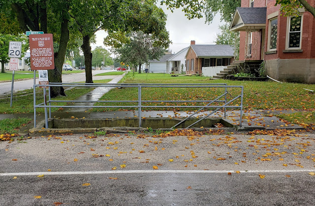 |
| Pedestrian tunnel under Route 66 at West Hamilton Street |
By the 1930s, Route 66 traffic through town was so bad that the residents built this tunnel so they could safely cross the street. This is in a residential neighborhood, not the business district! It’s easy to understand why Route 66 was rerouted to bypass Odell by the 1940s.
Two blocks further, at 400 South West Street, is a Route 66 gem: the beautifully restored Standard Oil gas station.
 |
| Odell Standard Oil gas station |
It was built in 1932 and is on the National Register of Historic Places. It’s now a visitors center, but unfortunately it was closed when we stopped by.
South of the Standard Oil gas station, South West Street rejoins Historic Route 66 (the bypass in the 1940s) and once again runs between I-55 and a railroad. Just north of Cayuga there’s supposed to be a barn with “Meramec Caverns” painted on the side, but we didn’t see it.
By the time we reached Cayuga, we noticed what looked like stretches of an abandoned concrete road running parallel to Route 66 on our right. The photo below is of the abandoned road, facing south, with the road we were driving to the left.
 |
| Now-abandoned 1940s Route 66 between Cayuga and Chenoa, Illinois (from Wikimedia Commons) |
The abandoned roadbed was once the 1920s Route 66 from Cayuga, through Pontiac, and on to Chenoa. It was paved with slabs of Portland cement that were 6 inches deep and 18 feet wide. That road could not support heavy wartime vehicles during World War II. So during the war, the road was paved over with new concrete, this time 10 inches deep and 24 feet wide. In the 1950s, Route 66 was expanded to a 4-lane highway by adding two lanes to the east—the road we were now driving on and that you can see on the left side of the photo.
Once I-55 was built, there was no need to maintain a four-late Route 66 alongside it. So the two southbound lanes—the original Route 66, topped with a new road during World War II—were simply abandoned and the two northbound lanes converted into a two-lane road.
Next stop: Pontiac, another one of Route 66’s gems.


No comments:
Post a Comment