After exploring Pontiac, Illinois, we passed through three more Illinois towns along Route 66: Lexington, Towanda, and Normal.
About a mile before Lexington, Route 66 veers away from I-55. About a half mile later, we turned left onto Parade Road, also known as Memory Lane. This is an original 1926 stretch of Route 66 that now has reproductions of vintage road signs.
 |
| Memory Lane in Lexington, Illinois |
I’d read that Memory Lane is often closed to vehicles, but it was open for driving when we visited in October 2021. With I-55 and the newer Route 66 bypass out of sight, we got a real sense of what it was like to travel on the original Route 66.
After Memory Lane, the original Route 66 becomes West Wall Street and then North Grove Street, rejoining the newer Route 66 bypass south of Lexington. Instead of following the original route all the way through town, we turned right (west) onto Main Street to try to see a restored 1949 neon sign pointing travelers from the bypass to downtown Lexington, but we somehow missed it.
 |
| Neon sign pointing to Lexington, Illinois (from TheRoadWanderer.net) |
A few miles further down Route 66 from Lexington is Towanda, Illinois. Back around Odell, Illinois, we saw stretches of an abandoned Route 66 roadbed that runs parallel to today’s Route 66. That abandoned roadbed appears again in Towanda. Here it’s been converted into a really nice roadside walking path, shown on Google Maps as Historic Route 66 Trail and sometimes called the Parkway or Route 66 Walking Tour.
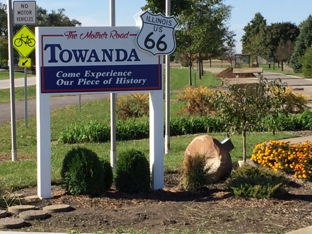 |
| Original Route 66 (on right) through Towanda, now a walking trail (from Route66 Towanda.org) |
The trail runs about 3 ½ miles. This would be a great place to stretch your legs.
 |
| Towanda's Dead Man's Curve (from CuriousTraveler66.wordpress.com) |
To reach it, turn right (north) at the intersection of Route 66 with South Jefferson Street on the left and North 1900 East Road on the right. Take the next left on Jackson Street. Jackson Street was once part of the 1926 “alignment” and soon take a sharp left turn onto Quincy Street. This is Dead Mans Curve. There are plenty of signs, including some Burma Shave signs, so you can’t miss it.
Illinois is mostly flat, so many of original roads
ran either north-south or east-west, in simple grid patterns. When Route 66 was
created in 1926, it was intended to run through Illinois on a diagonal, from
Chicago southwest to St. Louis, Missouri. In many sections there was no
existing diagonal road, so Route 66 zigzagged west and south, west and south,
along existing roads. This created a lot of sharp 90-degree turns. I’m sure
signage was poor in those days, and a lot of travelers didn’t expect those
turns and ended up tipping over.
I’m not sure why this particular segment is notorious as Dead Mans Curve when the 1926 “alignment” had many such sharp turns. Here the road is only 18 feet wide—maybe that narrow width contributed to more accidents than usual.
Quincy Street took us back to Route 66, and from there it was just a few miles into Normal and Bloomington, Illinois.
Normal got its odd name from the university it’s home to: Illinois State University. The university was founded in 1857 as Illinois State Normal University, a teachers college. American teachers colleges in the 1800s were called normal schools after the first teachers school, which was founded in France in the 1600s. It was called Ecole Normale because it educated teachers in the norms of the day. Illinois State Normal University was one of the first public teachers colleges in the United States. Here's what it looked like in 1914.
 |
| Illinois State Normal University in 1914 (from Library of Congress) |
Today Illinois State is huge, with about 20,000 studnets, and so is the community
around it. The town of Normal now blends into Bloomington to the south. The total
population of Normal and Bloomington is over 150,000.
We didn’t try to stay on Route 66 through Normal and Bloomington. Instead, we set our GPS to reach a Route 66 gem: the 1931 Sprague Super Service Station at 305 Pine Street in Normal.
 |
| 1931 Sprague Super Service Station in Normal, Illinois |
Sprague’s service station, on the National Register of Historic Places, is the only gas station in Illinois built in Tudor Revival style. It once had a restaurant on the first floor and apartments for the owner and an employee on the second floor. A Route 66 bypass built in the 1940s (now Veterans Parkway or Business I-55) ended Sprague’s heyday, and the building has housed a variety of businesses over the years. The National Park Service has a photo of what it looked like in 1966.
 |
| Sprague Super Service Station in 1966 (from nps.gov) |
Today it’s officially called Ryburn Place at Sprague’s Super Service. It’s a visitor center and gift shop owned by the Town of Normal. Unfortunately it was closed when we stopped by.
Half a block west at 208 Pine Street is another 1930s gas station: Snedaker’s Station.
 |
| Snedaker's Station in Normal, Illinois (from Google Maps) |
It is now a private home, but you can see the canopy where gas pumps once were.
Getting back on Route 66 south of Normal-Bloomington is a bit tricky. We took South Veterans Parkway. Just before it intersects with I-78 and I-55, we turned right (west) at the intersection with West Hamilton Road on the left and Historic Route 66 on the right. After crossing I-55/74, we turned left (south) to stay on Historic Route 66. It parallels I-55 on the northwest side.
About 8 miles south is Funks Grove Maple Sirup (yes, spelled that way) in Shirley, Illinois. Funks is a local institution since 1891. We had just visited Vermont a few months earlier, so we skipped Funks and continued to yet another Route 66 gem: Atlanta, Illinois.


No comments:
Post a Comment